Kyabobo National Park
| Kyabobo National Park | |
|---|---|
 | |
| Location | Volta Region of Ghana |
| Nearest city | Nkwanta |
| Coordinates | 8°25′N 0°37′E / 8.417°N 0.617°ECoordinates: 8°25′N 0°37′E / 8.417°N 0.617°E |
| Area | 360 km² |
| Established | 1997 |
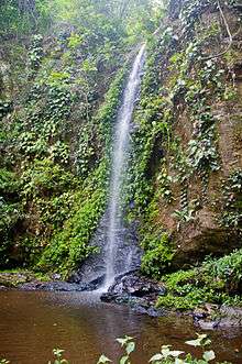
A small waterfall at Kyabobo National Park
Kyabobo National Park (pronounced CHAY-a-bobo) is a 360-square-kilometre (140 sq mi) national park in Ghana.[1][2]
Kyabobo is located in the Volta region on the border with Togo. The nearest town is Nkwanta.[1]
The reserve was established in 1997. Ghana's second highest mountain, Mount Dzebobo is contained within the park and offers visitors an impressive view of the Lake Volta.
The park is located in a transition zone between tropical rain forest and tree savanna. The Park's wildlife includes African bush elephants, African leopards, African buffalo, waterbuck, several primate species, bushbuck, duikers and, a symbol for the park, the rock hyrax. A park survey lists at least 500 species of butterflies and 235 birds.[1]
References
- 1 2 3 Ryman, Leif (30 April 2012). "Ecotourism in Ghana: Undiscovered Kyabobo - The Travel Word". Retrieved 17 October 2014.
- ↑ Parks and Reserves of Ghana: Management Effectiveness Assessment of Protected Areas (PDF). IUCN – International Union for Conservation of Nature. 2010. pp. 16–17. Retrieved February 10, 2017.
This article is issued from
Wikipedia.
The text is licensed under Creative Commons - Attribution - Sharealike.
Additional terms may apply for the media files.