Kvilda
| Kvilda | |||
| Village | |||
 Kvilda | |||
|
|||
| Country | Czech Republic | ||
|---|---|---|---|
| Region | South Bohemian | ||
| District | Prachatice | ||
| Elevation | 1,065 m (3,494 ft) | ||
| Coordinates | 49°1′9.3″N 13°34′46.48″E / 49.019250°N 13.5795778°ECoordinates: 49°1′9.3″N 13°34′46.48″E / 49.019250°N 13.5795778°E | ||
| Area | 45.17 km2 (17.44 sq mi) | ||
| Population | 139 (1.1.2017) | ||
| Density | 3/km2 (8/sq mi) | ||
| First mentioned | 1569 | ||
| Mayor | Václav Vostradovský | ||
| Timezone | CET (UTC+1) | ||
| - summer (DST) | CEST (UTC+2) | ||
| Postal code | 384 93 | ||
  Location in the Czech Republic | |||
| Wikimedia Commons: Kvilda | |||
| Website: Official website | |||


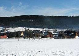
Kvilda (German: Außergefild) is a village in Prachatice District, South Bohemian Region, Czech Republic. It lies in Šumava region, in the elevation of 1,065 m, making it the highest-located municipality in the country.[1] It is also the coldest place in the Czech Republic with average annual temperature of 2 °C (36 °F). The average number of below-zero days per annum is 252.[2]
The sources of the Czech Republic's longest river Vltava are located in the cadastral area of the municipality.[1]
References
- 1 2 Kvilda: Nejvýše ležící obec je také ta nejchladnější at Prachatický Deník.cz, 1 September 2012
- ↑ Certifikát Nejstudenější místo v katastru obce Agentura Dobrý den Pelhřimov, 9 December 2011
External links
- (in Czech) Official website
| Wikimedia Commons has media related to Kvilda. |
This article is issued from
Wikipedia.
The text is licensed under Creative Commons - Attribution - Sharealike.
Additional terms may apply for the media files.