Borová Lada
| Borová Lada | |||
|---|---|---|---|
| Municipality | |||
 | |||
| |||
 Borová Lada | |||
| Coordinates: 48°59′23″N 13°39′35″E / 48.98972°N 13.65972°ECoordinates: 48°59′23″N 13°39′35″E / 48.98972°N 13.65972°E | |||
| Country |
| ||
| Region | South Bohemian | ||
| District | Prachatice | ||
| Area | |||
| • Total | 68.95 km2 (26.62 sq mi) | ||
| Elevation | 895 m (2,936 ft) | ||
| Population (2011) | |||
| • Total | 272 | ||
| Postal code | 384 92 | ||
| Website | http://www.borova-lada.cz | ||


| Wikimedia Commons has media related to Borová Lada. |
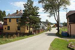
Borová Lada (German Ferchenhaid) is a village and municipality (obec) in Prachatice District in the South Bohemian Region of the Czech Republic. The village is surrounded by woods and moors and is located deep inside the Bohemian Forest. It is a small tourism resort for hiking and cross-country skiing.
Borová Lada lies approximately 25 kilometres (16 mi) west of Prachatice, 60 km (37 mi) west of České Budějovice, 134 km (83 mi) south-west of Prague, and 9 kilometres (6 mi) east of the border to Germany.
Borová Lada was founded as a hunting lodge by prince Franz Adam zu Schwarzenberg in 1721. In 1855, the population comprised 230 people, most of them ethnic Germans. After the Second World War they were expelled from the village along with their fellow countrymen from the whole region.
Gallery
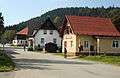 The Post office
 Vltava in Borová Lada
References