Krassó-Szörény County
| Krassó-Szörény County Comitatus Krassovinis et Severinensis (Latin) Krassó-Szörény vármegye (Hungarian) Komitat Karasch-Severin (German) Comitatul Caraș-Severin (Romanian) | |||||
| County of the Kingdom of Hungary | |||||
| |||||
.svg.png) | |||||
 | |||||
| Capital | Lugos 45°41′N 21°54′E / 45.683°N 21.900°ECoordinates: 45°41′N 21°54′E / 45.683°N 21.900°E | ||||
| History | |||||
| • | Established | 1881 | |||
| • | Treaty of Trianon | 4 June 1920 | |||
| Area | |||||
| • | 1910 | 11,074 km2 (4,276 sq mi) | |||
| Population | |||||
| • | 1910 | 466,147 | |||
| Density | 42.1 /km2 (109 /sq mi) | ||||
| Today part of | Romania, Serbia | ||||
| Lugoj is the current name of the capital. | |||||

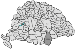
Krassó-Szörény (Hungarian: Krassó-Szörény, Romanian: Caraş-Severin, Serbian: Karaš-Severin or Караш-Северин) was an administrative county (comitatus) of the historic Kingdom of Hungary.[1] Its territory is now mostly located in south-western Romania, with one small part which is located in Serbia. The capital of the county was Lugos (present-day Lugoj).
Geography
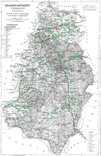
Krassó-Szörény county was located in the Banat region. It shared borders with the Kingdom of Serbia and the Hungarian counties Temes, Arad and Hunyad. The river Danube formed its southern border, and the river Maros its northern border. The river Temes flowed through the county. Its area was 11,032 km² around 1910.
History
Krassó-Szörény county was formed in 1881 by uniting the counties Krassó and Szörény.
In 1920 by the Treaty of Trianon most of the county was assigned to Romania, with one small part which was assigned to the Kingdom of Serbs, Croats and Slovenes. The north of the county (including Lugoj) is now part of the Romanian county Timiş, except a 10 km wide strip along the river Mureş, which is in the county Arad. The rest now forms the county Caraş-Severin, except the city Orşova, which is in Mehedinţi county.
Demographics

In 1900, the county had a population of 443,001 people and was composed of the following linguistic communities:[2]
Total:
- Romanian: 328,371 (74.1%)
- German: 55,256 (12.5%)
- Hungarian: 21,439 (4.8%)
- Serbian: 13,138 (3.0%)
- Slovak: 3,831 (0.9%)
- Ruthenian: 803 (0.2%)
- Croatian: 279 (0.0%)
- Other or unknown: 19,884 (4.5%)
According to the census of 1900, the county was composed of the following religious communities:[3]
Total:
- Eastern Orthodox: 325,613 (73.5%)
- Roman Catholic: 84,748 (19.1%)
- Greek Catholic: 18,262 (4.1%)
- Calvinist: 7,792 (1.8%)
- Jewish: 4,375 (1.0%)
- Lutheran: 2,043 (0.5%)
- Unitarian: 59 (0.0%)
- Other or unknown: 109 (0.0%)
In 1910, the county had a population of 466,147 people and was composed of the following linguistic communities:[4]
Total:
- Romanian: 336,082 (72.1%)
- German: 55,883 (12.0%)
- Hungarian: 33,787 (7.3%)
- Serbian: 14,674 (3.1%)
- Slovak: 2,908 (0.6%)
- Ruthenian: 2,351 (0.5%)
- Croatian: 319 (0.1%)
- Other or unknown: 20,143 (4.3%)
According to the census of 1910, the county was composed of the following religious communities:[5]
Total:
- Eastern Orthodox: 337,153 (72.4%)
- Roman Catholic: 90,479 (19.4%)
- Greek Catholic: 20,006 (4.3%)
- Calvinist: 10,400 (2.2%)
- Lutheran: 2,875 (0.6%)
- Jewish: 4,795 (1.0%)
- Unitarian: 142 (0.0%)
- Other or unknown: 297 (0.1%)
Subdivisions
In the early 20th century, the subdivisions of Krassó-Szörény county were:
| Districts (járás) | |
|---|---|
| District | Capital |
| Béga | Bálinc (Romanian: Balinț) |
| Boksanbánya | Boksanbánya (Romanian: Bocşa Montană) |
| Bozovics | Bozovics (Romanian: Bozovici) |
| Facsád | Facsád (Romanian: Făget) |
| Jám | Jám (Romanian: Iam) |
| Karánsebes | Karánsebes (Romanian: Caransebeş) |
| Lugos | Lugos (Romanian: Lugoj) |
| Maros | Marosberkes (Romanian: Birchiș) |
| Oravicabánya | Oravicabánya (Romanian: Oraviţa) |
| Resicabánya | Resicabánya (Romanian: Reşiţa) |
| Temes | Szákul (Romanian: Sacu) |
| Teregova | Teregova (Romanian: Teregova) |
| Újmoldova | Újmoldova (Romanian: Moldova Nouă) |
| Urban districts (rendezett tanácsú város) | |
| Karánsebes (Romanian: Caransebeş) | |
| Lugos (Romanian: Lugoj) | |
References
- ↑ Zoltán Gál, The banking functions of the Hungarian urban network in the early 20th century, Centre for Regional Studies, 2006, table 6
- ↑ "KlimoTheca :: Könyvtár". Kt.lib.pte.hu. Retrieved 2012-12-06.
- ↑ "KlimoTheca :: Könyvtár". Kt.lib.pte.hu. Retrieved 2012-12-06.
- ↑ "KlimoTheca :: Könyvtár". Kt.lib.pte.hu. Retrieved 2012-06-21.
- ↑ "KlimoTheca :: Könyvtár". Kt.lib.pte.hu. Retrieved 2012-06-21.

| Wikimedia Commons has media related to Krassó-Szörény County. |