Csík County
| Csík County Comitatus Csikiensis (Latin) Csík vármegye (Hungarian) Komitat Tschick (German) Comitatul Ciuc (Romanian) | |||||
| County of the Kingdom of Hungary | |||||
| |||||
 | |||||
 | |||||
| Capital | Csíkszereda 46°22′N 25°48′E / 46.367°N 25.800°ECoordinates: 46°22′N 25°48′E / 46.367°N 25.800°E | ||||
| History | |||||
| • | Established | 1876 | |||
| • | Treaty of Trianon | June 4, 1920 | |||
| Area | |||||
| • | 1910 | 5,064 km2 (1,955 sq mi) | |||
| Population | |||||
| • | 1910 | 145,720 | |||
| Density | 28.8 /km2 (74.5 /sq mi) | ||||
| Today part of | Romania | ||||
| Miercurea Ciuc is the current name of the capital. | |||||
Csík (Hungarian, in Romanian: Ciuc) was an administrative county (comitatus) of the Kingdom of Hungary. Its territory is now in central Romania (eastern Transylvania). The capital of the county was Csíkszereda (now Miercurea Ciuc).
Geography
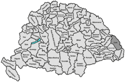
Csík county shared borders with Kingdom of Romania and the Hungarian counties Beszterce-Naszód, Maros-Torda, Udvarhely and Háromszék. The county was situated in the Carpathian Mountains, around the sources and upper courses of the rivers Olt and Maros. Its area was 4859 km² around 1910.
Demography
In 1891, the county had 114,110 inhabitants, according to ethnicity:
In 1900, the county had a population of 128,382 people and was composed of the following linguistic communities:[1]
Total:
- Hungarian: 110,963 (86,4%)
- Romanian: 15,936 (12,4%)
- German: 1,062 (0,8%)
- Slovak: 43 (0,0%)
- Ruthenian: 38 (0,0%)
- Croatian: 6 (0,0%)
- Serbian: 1 (0,0%)
- Other or unknown: 333 (0,3%)
According to the census of 1900, the county was composed of the following religious communities:[2]
Total:
- Roman Catholic: 104,287 (81,2%)
- Greek Catholic: 21,100 (16,4%)
- Jewish: 1,518 (1,2%)
- Calvinist: 956 (0,8%)
- Lutheran: 241 (0,2%)
- Greek Orthodox: 169 (0,1%)
- Unitarian: 103 (0,1%)
- Other or unknown: 8 (0,0%)
In 1910, county had a population of 145,720 people and was composed of the following linguistic communities:[3]
Total:
- Hungarian: 125,888 (86,4%)
- Romanian: 18,032 (12,4%)
- German: 1,080 (0,7%)
- Ruthenian: 188 (0,1%)
- Slovak: 85 (0,06%)
- Serbian: 3 (0,0%)
- Croatian: 13 (0,0%)
- Other or unknown: 431 (0,3%)
According to the census of 1910, the county was composed of the following religious communities:[4]
Total:
- Roman Catholic: 117,351 (80,5%)
- Greek Catholic: 23,724 (16,3%)
- Jewish: 2,357 (1,6%)
- Calvinist: 1,689 (1,2%)
- Lutheran: 263 (0,2%)
- Greek Orthodox: 188 (0,1%)
- Unitarian: 140 (0,1%)
- Other or unknown: 8 (0,0%)
History
The Csík region was a combination of three settlements (seats) of the Székely: Csíkszék, Gyergyószék and Kászonszék. Csík county was formed in 1876, when the administrative structure of Transylvania was changed. In 1920 the Treaty of Trianon assigned the territory of Csík county to the Kingdom of Romania. It returned to Hungary with the Second Vienna Award of 1940, but was given again to Romania at the end of World War II. Its territory lies in the present-day Romanian counties Harghita and Neamţ (a small part in the north-east).
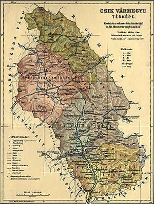
Subdivisions
In the early 20th century, the subdivisions of Csík county were:
| Districts (járás) | |
|---|---|
| District | Capital |
| Felcsík | Csíkszereda, (Romanian: Miercurea Ciuc) |
| Gyergyószentmiklós | Gyergyószentmiklós, (Romanian: Gheorgheni) |
| Gyergyótölgyes | Gyergyótölgyes, (Romanian: Tulgheș) |
| Kászonalcsík | Csíkszentmárton, (Romanian: Sânmartin) |
| Szépvíz | Szépvíz, (Romanian: Frumoasa) |
| Urban districts (rendezett tanácsú város) | |
| Csíkszereda, (Romanian: Miercurea Ciuc) | |
| Gyergyószentmiklós, (Romanian: Gheorgheni) | |
References
- ↑ "KlimoTheca :: Könyvtár". Kt.lib.pte.hu. Retrieved 2012-12-07.
- ↑ "KlimoTheca :: Könyvtár". Kt.lib.pte.hu. Retrieved 2012-12-07.
- ↑ "KlimoTheca :: Könyvtár". Kt.lib.pte.hu. Retrieved 2012-06-19.
- ↑ "KlimoTheca :: Könyvtár". Kt.lib.pte.hu. Retrieved 2012-06-19.
