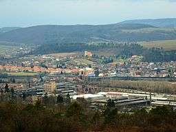
Králův Dvůr
| Králův Dvůr | |||
| Town | |||
 Králův Dvůr | |||
|
|||
| Country | Czech Republic | ||
|---|---|---|---|
| Region | Central Bohemian | ||
| District | Beroun | ||
| Commune | Beroun | ||
| River | Litavka | ||
| Elevation | 240 m (787 ft) | ||
| Coordinates | 49°56′48″N 14°2′6″E / 49.94667°N 14.03500°ECoordinates: 49°56′48″N 14°2′6″E / 49.94667°N 14.03500°E | ||
| Area | 15.26 km2 (5.89 sq mi) | ||
| Population | 6,425 (2008-01-01) | ||
| Density | 421/km2 (1,090/sq mi) | ||
| First mentioned | 1253 | ||
| Mayor | Karel Mencl | ||
| Timezone | CET (UTC+1) | ||
| - summer (DST) | CEST (UTC+2) | ||
| Postal code | 267 01 | ||
  Location in the Czech Republic | |||
| Wikimedia Commons: Králův Dvůr | |||
| Statistics: statnisprava.cz | |||
| Website: www.kraluv-dvur.cz | |||
Králův Dvůr (pronounced [ˈkraːluːf dvuːr], German: Königshof) is a town in the Central Bohemian Region of the Czech Republic. It is located very close to Beroun. It has a population of 6,201 (2006).
History
The first mention of this town was written in 1394. In the first half of the 13th century, Wenceslaus I probably built a medieval yard in this town.
In 1930, Králův Dvůr attained the status of městys. It was upgraded to town on 5 October 2004.[2]
Since 1988, a D5 motorway has led through the town, which caused the town to not have a natural town centre.
External links
| Wikimedia Commons has media related to Králův Dvůr. |
This article is issued from
Wikipedia.
The text is licensed under Creative Commons - Attribution - Sharealike.
Additional terms may apply for the media files.