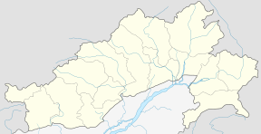
Deomali
| Deomali | |
|---|---|
| city | |
 Deomali Location in Arunachal Pradesh, India  Deomali Deomali (India) | |
| Coordinates: 27°09′31″N 95°28′41″E / 27.15857°N 95.47816°ECoordinates: 27°09′31″N 95°28′41″E / 27.15857°N 95.47816°E | |
| Country |
|
| State | Arunachal Pradesh |
| District | Tirap |
| Population (2001) | |
| • Total | 6,060 |
| Languages | |
| • Official | English |
| Time zone | UTC+5:30 (IST) |
| ISO 3166 code | IN-AR |
| Vehicle registration | AR |
Deomali is a census town in Tirap district in the state of Arunachal Pradesh, India.
Geography
Deomali is located at 27.1585'N, 95.47816'E.
Demographics
As of 2011 India census,[1] Deomali had a population of 6060. Males constitute 53% of the population and females 47%. Deomali has an average literacy rate of 62%, higher than the national average of 59.5%: male literacy is 69% and, female literacy is 55%. In Deomali, 17% of the population is under 6 years of age. In 2001 Tirap Government College was shifted to Deomali from Khonsa. Presently, the college name is Wangcha Rajkumar Government College and it has 13 faculty members and 327 students.
Deomali is under 54th Namsang Assembly Constituency and it is one of the 60 Assembly Constituency of Arunachal Pradesh. The current MLA is Wangki Lowang (March, 2017)
Media
Deomali has an All India Radio Relay station known as Akashvani Deomali. It broadcasts on FM frequencies.
Tribe
Nocte is the principal tribe inhabiting in Deomali and its nearby villages, some small population of Wancho, Tutsa, Adi, Nyishi, Galo, Assamese, Bengali and Bihari are also found here.
Festivals
Festivals like Durga Puja, Diwali, Christmas etc. are celebrated in Deomali but its main festival is Chalo Loku which belongs to the Nocte tribe and celebrated on 25th of November every year.
Education
There are only few Government and Private educational institutions in Deomali which are:
Schools
- Ramakrishna Mission School, Narottam Nagar.
- Government Higher Secondary School.
- St. George School.
- Sun Hum Primary School.
- Ang Kids School.
- Good Sepherd School.
Colleges
- Wangcha Rajkumar Government College.
Attractions
Deomali has few tourists sites but Chatjo River, Ramakrishna Mission Campus, St. George Catholic Church and nearby villages are the best attractions in Deomali but, in the month of November, tourists can witness the Chalo Loku festival which is celebrated with great joy in Deomali.
Transport
Buses and cars operating from Deomali to other places are:
- Deomali-Khonsa (Tata Sumo) 50 km
- Deomali-Longding (Tata Sumo) 90 km
- Deomali-Miao (APSTS Bus) 90 km
- Deomali-Itanagar (Network Travels Bus & Deep Travels Bus) 508 km
- Deomali-Tinsukia (Private Bus) 60 km
- Deomali-Margherita (APSTS & Private Bus) 20 km
- Deomali-Dibrugarh (Hired Cars) 75 km
Direct buses and cars are available from Itanagar, Dibrugarh and Tinsukia to Deomali, but people travelling from other places via Guwahati can also reach Deomali through connecting buses or wingers which ply on daily basis from Tinsukia and Dibrugarh. The town of Deomali is connected to the closest state of Assam through Naharkatia in Dibrugarh district and also through Margherita in Tinsukia district. Both the towns Naharkatia and Margherita in Assam are at a distance of 20 KM from Deomali, and these two towns cater Indian Railway services to the people of Deomali as well as to the people of Khonsa the district headquarters of Tirap. The nearest domestic airport is Mohanbari Airport at Dibrugarh which is 75 KM away and can be travelled via Naharkatia, Duliajan route. Private cars travel in this area all day but regular bus or any other service to Deomali from Tinsukia and Dibrugarh are not available after 12 noon, and hence travelling in morning hours is a wise option.
Recently the Railway Ministry has sanctioned eight new railway lines :
- Itakhola–Seijosa (18 km),
- Doomdooma –Namsai– Wakro (96 km)
- Dangri – Roing (60 km)
- Naharkatia – Deomali (20 km)
- Lekhapani-Nampong – New Khamlang – Deben (75 km)
- Tinsukia – Pasighat via Kanubari (300 km)
References
- ↑ "Census of India 2001: Data from the 2001 Census, including cities, villages and towns (Provisional)". Census Commission of India. Archived from the original on 2004-06-16. Retrieved 2008-11-01.