Konibodom
| Konibodom | |
|---|---|
| Town and Jamoat | |
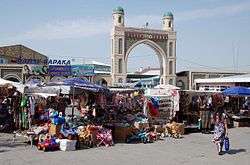 Konibodom, the bazar. | |
| Coordinates: 40°17′N 70°25′E / 40.283°N 70.417°E | |
| Country |
|
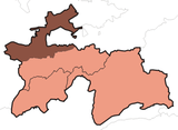
| Province | Sughd |
| Founded | 7th century |
| Government | |
| • Type | Republic |
| • Chief | Shamsiddinov Hiloliddin |
| Area | |
| • Town and Jamoat | 67 km2 (26 sq mi) |
| • Urban | 829 km2 (320 sq mi) |
| Elevation[1] | 410 m (1,350 ft) |
| Population (2007 est.)[2] | |
| • Urban | 47,100 |
| Time zone | UTC+5 |
| Website |
www |
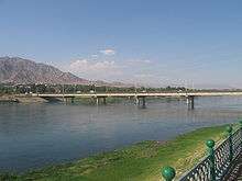
Konibodom (Tajik: Конибодом) is a city and jamoat in the Sughd province of northern Tajikistan, in western Fergana Valley.[1] It has a population of 47,100 (2007 Estimate).[2]
Geography
Climate
The Köppen Climate Classification sub-type for Konibodom is "BSk" or a Tropical and Subtropical Steppe Climate. The average annual temperature is 14°C (57.2°F). The warmest month is July with an average temperature of 27.4°C (81.3°F) and the coolest month is January with an average temperature of -0.6°C (30.9°F). The average annual precipitation is 465.5mm (18.3") and has an average of 68.9 days with precipitation. The wettest month is March with an average of 77.7mm (3.1") of precipitation and the driest month is August with an average of 1.9mm (0.08") of precipitation.[1]
| Climate data for Konibodom | |||||||||||||
|---|---|---|---|---|---|---|---|---|---|---|---|---|---|
| Month | Jan | Feb | Mar | Apr | May | Jun | Jul | Aug | Sep | Oct | Nov | Dec | Year |
| Daily mean °C (°F) | −0.6 (30.9) |
1.7 (35.1) |
8.6 (47.5) |
16.0 (60.8) |
21.0 (69.8) |
25.6 (78.1) |
27.4 (81.3) |
25.3 (77.5) |
20.4 (68.7) |
13.8 (56.8) |
7.3 (45.1) |
1.9 (35.4) |
14.0 (57.2) |
| Average precipitation mm (inches) | 52.1 (2.051) |
54.9 (2.161) |
77.7 (3.059) |
69.9 (2.752) |
52.3 (2.059) |
12.0 (0.472) |
7.7 (0.303) |
1.9 (0.075) |
5.0 (0.197) |
39.7 (1.563) |
43.0 (1.693) |
49.3 (1.941) |
465.5 (18.327) |
| Average precipitation days (≥ 0.1 mm) | 7.6 | 8.0 | 9.4 | 9.1 | 8.1 | 3.6 | 1.9 | 1.1 | 1.7 | 5.1 | 6.0 | 7.3 | 68.9 |
| Average relative humidity (%) | 75.7 | 73.0 | 65.1 | 58.1 | 49.9 | 39.2 | 39.5 | 43.1 | 46.1 | 56.7 | 66.8 | 75.3 | 57.4 |
| Source: "The Climate of Konibodom". Weatherbase. Retrieved 4 August 2014. | |||||||||||||
Notable people
- Sa'diniso Hakimova, obstetrician and gynecologist[3]
- Lutfi Zohidova, ballet dancer[4]
See also
References
- 1 2 3 "Climate of Konibodom". Weatherbase.com. Retrieved 7 August 2014.
- 1 2 Population of the Republic of Tajikistan as of 1 January 2008, State Committee of Statistics, Dushanbe, 2008 (in Russian)
- ↑ "Haidarshoev, Muhammadali - P rominent t ajik f igures of the". fayllar.org. Retrieved 12 November 2017.
- ↑ "Yusufov, Hakim - P rominent t ajik f igures of the". fayllar.org. Retrieved 10 November 2017.
Coordinates: 40°17′N 70°25′E / 40.283°N 70.417°E