Istaravshan District
| Istaravshan District | |
|---|---|
| District | |
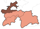
 Location of Istaravshan District in Tajikistan | |
| Country |
|
| Province | Sughd |
| Capital | Istaravshan |
| Time zone | UTC+5 (TJT) |
Istaravshan District or Nohiya-i Istaravshan (Tajik: Ноҳияи Истаравшан), formerly Uroteppa (or Ura-Tyube) District (Tajik: Уротеппа, Russian: Ура-Тюбе), is a district in the central part of Sughd province, Tajikistan, between the border with Uzbekistan to the west and Ghonchi district to the east.[1] Its capital is Istaravshan (called Ura-Tyube until 2000).
Administrative divisions
The district is divided administratively into jamoats. They are as follows (and population).[2]
| Jamoats of Istaravshan District | |||||||||||
| Jamoat | Population | ||||||||||
|---|---|---|---|---|---|---|---|---|---|---|---|
| Frunze | 11058 | ||||||||||
| Guli Surkh | 28799 | ||||||||||
| Javkandak | 7535 | ||||||||||
| Kommunizm | 22190 | ||||||||||
| Leninobod | 11468 | ||||||||||
| Nijoni | 7747 | ||||||||||
| Nofaroj | 7343 | ||||||||||
| Poshkent | 13292 | ||||||||||
| Pravda | 11652 | ||||||||||
| Qalaibaland | 6759 | ||||||||||
References
- ↑ Republic of Tajikistan, map showing administrative division as of January 1, 2004, "Tojjikoinot" Cartographic Press, Dushanbe
- ↑ "List of Jamoats". UN Coordination, Tajikistan. Archived from the original on July 16, 2011. Retrieved April 4, 2009.
This article is issued from
Wikipedia.
The text is licensed under Creative Commons - Attribution - Sharealike.
Additional terms may apply for the media files.