Kolazhy Grama Panchayat
| Kolazhy Grama Panchayat കോലഴി ഗ്രാമ പഞ്ചായത്ത് Kolazhy GP | |
|---|---|
| Grama Panchayat | |
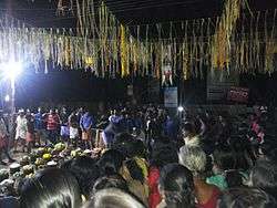 Kolazhy Pooram festival | |
| Coordinates: 10°35′06″N 76°12′56″E / 10.585016°N 76.215475°ECoordinates: 10°35′06″N 76°12′56″E / 10.585016°N 76.215475°E | |
| Country | India |
| State | Kerala |
| District | Thrissur |
| Taluk | Thrissur |
| Block | Puzhakkal Block Panchayat |
| Lok Sabha Constituency | Alathur (Constituency #9) |
| നിയമസഭ (Niyamasabha) (or Vidhan Sabha or Legislative Assembly) Constituency | Wadakkanchery (Constituency #65) |
| Government | |
| • Type | Grama Panchayat |
| • Body | Kolazhy Grama Panchayat |
| Area | |
| • Total | 4.64 km2 (1.79 sq mi) |
| Elevation | 14 m (46 ft) |
| Demonym(s) | Kolazhykaran |
| Languages | |
| • Official | Malayalam, English |
| Time zone | UTC+5:30 (IST) |
| Postal Index Number (PIN) | 680581 - Tirur (Mulagunnathukavu) PO |
| Telephone code | +91-487 |
| Vehicle registration | KL-08 |
| Climate | Tropical monsoon (Köppen Am) |
| Website | http://lsgkerala.in/kolazhypanchayat/ |
Kolazhy Grama Panchayat (Malayalam: കോലഴി ഗ്രാമ പഞ്ചായത്ത്), also known as Kolazhy GP, is part of Puzhakkal block, in Thrissur taluk, in Thrissur district.[1] It is located 6.8 kilometres (4.2 mi) north of Thrissur city.
The group of villages forming the wards given in the table below are governed by Kolazhy Grama Panchayat, Puzhakkal Block Panchayat and Thrissur District Panchayat.
Demographics
As of 2001 India census,[2] Kolazhy had a population of 8445. Males constitute 49% of the population and females 51%. Kolazhy has an average literacy rate of 85%, higher than the national average of 59.5%: male literacy is 86%, and female literacy is 84%. In Kolazhy, 10% of the population is under 6 years of age. The maximum populations are migrated here for residential purposes, as they maximum belongs employees of Govt. & private offices.
History
In ancient days it was then part of Vijayapuram "pravrithi" in Trichur "taluq".[3]
For the purposes of census, Kolazhy Grama Panchayat is divided into three census towns of Kolazhy (CT), Kuttur (CT) and Pottore (CT).
| # | Kolazhy Grama Panchayat
Ward # - Name |
Puzhakkal Block Panchayat
Ward # - Name |
Thrissur District Panchayat
Ward # - Name |
Census Town |
|---|---|---|---|---|
| 1 | 01 - Kunnathupeedika | 08 - Kunnathupeedika | 08 - Avanur | Pottore (CT) |
| 2 | 02 - Attore North | 08 - Kunnathupeedika | 08 - Avanur | Pottore (CT) |
| 3 | 03 - Pottore North | 08 - Kunnathupeedika | 08 - Avanur | Pottore (CT) |
| 4 | 04 - Thiroor | 09 - Kolazhy | 08 - Avanur | Kolazhy (CT) |
| 5 | 05 - Puthanmadamkunnu | 09 - Kolazhy | 08 - Avanur | Kolazhy (CT) |
| 6 | 06 - Athekkad | 09 - Kolazhy | 08 - Avanur | Kolazhy (CT) |
| 7 | 07 - Kolazhy North | 09 - Kolazhy | 08 - Avanur | Kolazhy (CT) |
| 8 | 08 - Kolazhy Centre | 09 - Kolazhy | 08 - Avanur | Kolazhy (CT) |
| 9 | 09 - Poovany | 09 - Kolazhy | 08 - Avanur | Kolazhy (CT) |
| 10 | 10 - Kolazhy West | 09 - Kolazhy | 08 - Avanur | Kolazhy (CT) |
| 11 | 11 - Pottore South | 08 - Kunnathupeedika | 08 - Avanur | Pottore (CT) |
| 12 | 12 - Attore South | 08 - Kunnathupeedika | 08 - Avanur | Pottore (CT) |
| 13 | 13 - Pamboor | 08 - Kunnathupeedika | 08 - Avanur | Kuttur (CT) |
| 14 | 14 - Kuttur East | 08 - Kunnathupeedika | 08 - Avanur | Kuttur (CT) |
| 15 | 15 - Kuttur West | 08 - Kunnathupeedika | 08 - Avanur | Kuttur (CT) |
| 16 | 16 - Kuttur North | 08 - Kunnathupeedika | 08 - Avanur | Kuttur (CT) |
| 17 | 17 - Kottekkad | 08 - Kunnathupeedika | 08 - Avanur | Kuttur (CT) |

Education
References
- ↑ Kolazhy Grama Panchayat Details
- ↑ "Census of India 2001: Data from the 2001 Census, including cities, villages and towns (Provisional)". Census Commission of India. Archived from the original on 2004-06-16. Retrieved 2008-11-01.
- ↑ Kingdom of Cochin Census of 1891