Koh Pring
| Native name: កោះព្រីង | |
|---|---|
 Koh Pring island off Sihanoukville's coast | |
 Koh Pring | |
| Geography | |
| Location | Cambodia - South East Asia |
| Coordinates | 10°22′N 102°57′E / 10.367°N 102.950°E |
| Area | 0.778 km2 (0.300 sq mi) |
| Length | 1.76 km (1.094 mi) |
| Width | 0.2–0.7 km (0.12–0.43 mi) |
| Coastline | 4.78 km (2.97 mi) |
| Administration | |
|
Cambodia | |
| Demographics | |
| Ethnic groups | Khmer |
Koh Pring, (Khmer: កោះព្រីង, Jambul Island, Koh Prins(former French name) is a Cambodian island in the gulf of Thailand, 64 km off the coastal city of Sihanoukville. Official sources provide no data of civilian communities on the "Outer Islands". Administration falls to the Cambodian navy, as the island lies within the national marine border in which it represents an isolated outpost.[1]
Geography
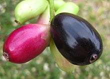
Jambul (Pring) fruits
Koh Pring is in fact the largest island of a tiny archipelago of 3 islands (Koh Pring, Koh Doung and Koh Trangol). Pring - ព្រីង - is Khmer for Jambul (jambolan, jamblang, or jamun), the fruit of an evergreen, flowering tropical tree.[2]
See also
References
- ↑ "List of Islands". Cambodia islands – Island Species Cambodia. Retrieved December 17, 2017.
- ↑ "Kaoh Pring". 1worldmap. Retrieved 5 May 2016.
This article is issued from
Wikipedia.
The text is licensed under Creative Commons - Attribution - Sharealike.
Additional terms may apply for the media files.