Koduru, Krishna district
| Koduru | |
|---|---|
| Village | |
 Temporal | |
 Koduru Location in Andhra Pradesh, India  Koduru Koduru (India) | |
| Coordinates: 16°00′08″N 81°02′30″E / 16.00222°N 81.04167°ECoordinates: 16°00′08″N 81°02′30″E / 16.00222°N 81.04167°E | |
| Country | India |
| State | Andhra Pradesh |
| District | Krishna |
| Mandal | Koduru |
| Government | |
| • Type | Gram panchayat |
| Area[1] | |
| • Total | 35.33 km2 (13.64 sq mi) |
| Population (2011)[2] | |
| • Total | 3,228 |
| • Density | 91/km2 (240/sq mi) |
| Languages | |
| • Official | Telugu |
| Time zone | UTC+5:30 (IST) |
| PIN | 521 328 |
| Telephone code | +91–8671 |
| Vehicle registration | AP 16 U |
| Website | www.koduru.com (under construction) |
Koduru is a village in Krishna district of the Indian state of Andhra Pradesh.[1]
Demographics
As of 2015 Census of India, the town had a population of 6000 aprx. The total population constitute, 3,023 males and 2,977 females —a sex ratio of 987 females per 1000 males, higher than the national average of 940 per 1000.[2][3] 1,252 children are in the age group of 0–6 years, of which 646 are boys and 606 are girls—a ratio of 938 per 1000. The average literacy rate stands at 73.68% with 4,000 aprx. literates, approximately equal to the national average of 73.00%.
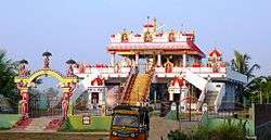
Famous places nearby includes "Sagara Sangam beach" and "Venu Gopala Swami Temple". [2][4]
See also
References
- 1 2 "District Census Handbook - Krishna" (PDF). Census of India. p. 16,244. Retrieved 15 February 2016.
- 1 2 3 "Census 2011". The Registrar General & Census Commissioner, India. Retrieved 10 August 2014.
- ↑ "Sex Ratio". The Registrar General & Census Commissioner, India. Retrieved 1 September 2014.
- ↑ "Chapter–3 (Literates and Literacy rate)" (PDF). Registrar General and Census Commissioner of India. Retrieved 1 September 2014.
This article is issued from
Wikipedia.
The text is licensed under Creative Commons - Attribution - Sharealike.
Additional terms may apply for the media files.