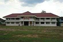
Ban Ta Khun District
| Ban Ta Khun บ้านตาขุน | |
|---|---|
| Amphoe | |
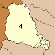
 Amphoe location in Surat Thani Province | |
| Coordinates: 8°54′18″N 98°53′6″E / 8.90500°N 98.88500°ECoordinates: 8°54′18″N 98°53′6″E / 8.90500°N 98.88500°E | |
| Country | Thailand |
| Province | Surat Thani |
| Seat | Khao Wong |
| Area | |
| • Total | 1,308.2 km2 (505.1 sq mi) |
| Population (2005) | |
| • Total | 14,116 |
| • Density | 10.8/km2 (28/sq mi) |
| Time zone | UTC+7 (ICT) |
| Postal code | 84230 |
| Geocode | 8409 |
Ban Ta Khun (Thai: บ้านตาขุน, pronounced [bâːn tāː kʰǔn]) is an amphoe in the west of Surat Thani Province of southern Thailand. It is both the largest district of the province and the one with the lowest population density.
Geography
Most of the district is in the hills of the Phuket Range, with parts being protected within Khao Sok National Park and the Khlong Saeng Wildlife Sanctuary. Mostly located in Ranong Province is the Khlong Nakha Wildlife Sanctuary, which covers the northwestern corner of the district.
The main rivers of the district is the Khlong Saeng, which is dammed by the Ratchaprapha dam to form the Cheow Lan reservoir. It empties near the town Khao Wong into the Phum Duang River.
Neighboring districts are (from north clockwise) Tha Chang, Vibhavadi, Khiri Rat Nikhom and Phanom of Surat Thani, Khura Buri of Phang Nga Province, and Suk Samran and Kapoe of Ranong Province.
History
The district was created on 20 July 1973 as a minor district (king amphoe) by splitting off five tambon from Khiri Rat Nikhom.[1]
On 9 September 1976 the minor district was elevated to full district status.[2]
The fifth tambon Krai Son (ไกรสร) was later merged into Khao Phang,[3] as it was in the area flooded by Cheow Lan lake.
Symbols
The slogan of the district is "High mountains, beautiful dam, rich in fruits, outstanding virtue, origin of the trunks for the city pillar".
Administration
The district is divided into four tambons, which are further subdivided into 29 villages (muban). There are two sub-district municipalities (thesaban tambon): Khao Wong (to be renamed Ban Ta Khun) covers 7.8 km2 of tambon Khao Wong, and Khao Pang 10.1 km2 of tambon Khao Pang. Each of the four tambons, except the areas covered by the municipalities, is administered by a tambon administrative organization (TAO).
|
 |
References
- ↑ ประกาศกระทรวงมหาดไทย เรื่อง แบ่งท้องที่อำเภอคีรีรัฐนิคม จังหวัดสุราษฎร์ธานี ตั้งเป็นกิ่งอำเภอบ้านตาขุน (PDF). Royal Gazette (in Thai). 90 (86 ง): 2153. July 17, 1973.
- ↑ พระราชกฤษฎีกาตั้งอำเภอเลาขวัญ อำเภอคำม่วง อำเภอพิปูน อำเภอศรีเทพ อำเภอนาแห้ว อำเภอส่องดาว อำเภอควนกาหลง อำเภอค่ายบางระจัน อำเภอบ้านตาขุน และอำเภอกุดจับ พ.ศ. ๒๕๑๙ (PDF). Royal Gazette (in Thai). 93 (109 ก special): 31–34. September 8, 1976.
- ↑ ประกาศกระทรวงมหาดไทย เรื่อง ยุบและเปลี่ยนแปลงเขตตำบล ในท้องที่อำเภอบ้านตาขุน จังหวัดสุราษฎร์ธานี (PDF). Royal Gazette (in Thai). 103 (218 ง): 117–119. December 12, 1986.
External links
- amphoe.com
- Website of district ( ( 2009-10-25) (Thai)