Ban Na Doem District
| Ban Na Doem บ้านนาเดิม | |
|---|---|
| Amphoe | |
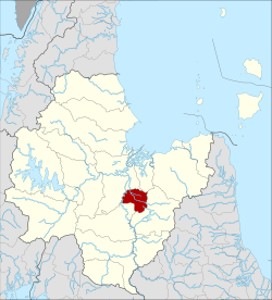 Amphoe location in Surat Thani Province | |
| Coordinates: 8°53′6″N 99°18′36″E / 8.88500°N 99.31000°ECoordinates: 8°53′6″N 99°18′36″E / 8.88500°N 99.31000°E | |
| Country | Thailand |
| Province | Surat Thani |
| Seat | Ban Na |
| Area | |
| • Total | 207.3 km2 (80.0 sq mi) |
| Population (2005) | |
| • Total | 21,797 |
| • Density | 105.1/km2 (272/sq mi) |
| Time zone | UTC+7 (ICT) |
| Postal code | 84240 |
| Geocode | 8413 |
Ban Na Doem (Thai: บ้านนาเดิม, pronounced [bâːn nāː dɤ̄ːm]) is a district (amphoe) of Surat Thani Province, Thailand.
Geography
Ban Na Doem is in the center of Surat Thani Province. Neighboring district are (from the north clockwise) Mueang Surat Thani, Ban Na San, Khian Sa, and Phunphin.
The Tapi River forms part of the western boundary of the district. A smaller river in the district is the Khlong Lamphun.
History
Lamphun District, one of the original districts of Surat Thani Province, was administered from the town of Ban Na, which is now the center of the Ban Na Doem District. On 1 July 1938, however, the district office was moved to Na San and the district was renamed Ban Na San one year later.
Effective 25 April 1976 the area around Ban Na was split off from Ban Na San District and formed a new minor district (king amphoe).[1] The minor district was originally divided into two tambon, Ban Na and Tha Ruea. On 15 August 1982 the tambon Sap Thawi was split from off Tha Ruea, and on 1 July 1983, Na Tai from Ban Na.
On 21 May 1990 the minor district was elevated to full district status.[2]
Administration
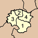
Ban Na Doem is divided into four sub-districts (tambon), which are further subdivided into 30 villages (muban). There is one township (thesaban tambon), Ban Na, covering parts of tambon Ban Na and Na Tai. Each tambon has a tambon administrative organization (TAO), responsible for the area not covered by the township.
|
 |
References
- ↑ ประกาศกระทรวงมหาดไทย เรื่อง แบ่งท้องที่อำเภอบ้านนาสาร จังหวัดสุราษฎร์ธานี ตั้งเป็นกิ่งอำเภอบ้านนาเดิม (PDF). Royal Gazette (in Thai). 93 (58 ง): 857. 13 Apr 1976.
- ↑ พระราชกฤษฎีกาตั้งอำเภอห้วยผึ้ง อำเภอวังวิเศษ อำเภอคลองหาด อำเภอป่าบอน อำเภอหนองหญ้าปล้อง อำเภอวังโป่ง อำเภอควนเนียง อำเภอหนองหญ้าไซ อำเภอบ้านนาเดิม อำเภอทุ่งฝน อำเภอสร้างคอม และอำเภอทองแสนขัน พ.ศ. ๒๕๓๓ (PDF). Royal Gazette (in Thai). 107 (83 ก special): 1–4. 21 May 1994.
External links
- http://www.amphoe.com/menu.php?am=705&pv=66&mid=1
- http://www.suratthani.go.th/suratpoc/aumphur/bannadeom.doc (Thai only)
- http://cddweb.cdd.go.th/bannadoem/ (Thai only)