Knobel, Arkansas
| Knobel, Arkansas | |
|---|---|
| City | |
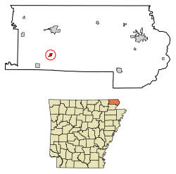 Location of Knobel in Clay County, Arkansas. | |
| Coordinates: 36°19′10″N 90°36′6″W / 36.31944°N 90.60167°WCoordinates: 36°19′10″N 90°36′6″W / 36.31944°N 90.60167°W | |
| Country | United States |
| State | Arkansas |
| County | Clay |
| Area[1] | |
| • Total | 0.42 sq mi (1.09 km2) |
| • Land | 0.42 sq mi (1.09 km2) |
| • Water | 0.00 sq mi (0.00 km2) |
| Elevation | 279 ft (85 m) |
| Population (2010) | |
| • Total | 287 |
| • Estimate (2017)[2] | 267 |
| • Density | 634.20/sq mi (244.97/km2) |
| Time zone | UTC-6 (Central (CST)) |
| • Summer (DST) | UTC-5 (CDT) |
| ZIP code | 72435 |
| Area code(s) | 870 |
| FIPS code | 05-37240 |
| GNIS feature ID | 0058025 |
Knobel is a city[3] in Clay County, Arkansas, United States. The population was 287 at the 2010 census.
Geography
Knobel is located at 36°19′10″N 90°36′6″W / 36.31944°N 90.60167°W (36.319360, -90.601780).[4]
According to the United States Census Bureau, the town has a total area of 1.1 km² (0.4 mi²), all land.
Demographics
| Historical population | |||
|---|---|---|---|
| Census | Pop. | %± | |
| 1900 | 410 | — | |
| 1910 | 362 | −11.7% | |
| 1920 | 390 | 7.7% | |
| 1930 | 486 | 24.6% | |
| 1940 | 375 | −22.8% | |
| 1950 | 417 | 11.2% | |
| 1960 | 339 | −18.7% | |
| 1970 | 375 | 10.6% | |
| 1980 | 503 | 34.1% | |
| 1990 | 317 | −37.0% | |
| 2000 | 358 | 12.9% | |
| 2010 | 287 | −19.8% | |
| Est. 2017 | 267 | [2] | −7.0% |
| U.S. Decennial Census[5] | |||
As of the census[6] of 2000, there were 358 people, 144 households, and 101 families residing in the town. The population density was 329.1/km² (860.1/mi²). There were 156 housing units at an average density of 143.4/km² (374.8/mi²). The racial makeup of the town was 97.77% White, 0.56% Black or African American and 1.68% Native American. 2.79% of the population were Hispanic or Latino of any race.
There were 144 households out of which 34.0% had children under the age of 18 living with them, 56.3% were married couples living together, 8.3% had a female householder with no husband present, and 29.2% were non-families. 26.4% of all households were made up of individuals and 16.0% had someone living alone who was 65 years of age or older. The average household size was 2.49 and the average family size was 2.95.
In the town, the population was spread out with 27.9% under the age of 18, 9.5% from 18 to 24, 29.3% from 25 to 44, 18.7% from 45 to 64, and 14.5% who were 65 years of age or older. The median age was 34 years. For every 100 females, there were 103.4 males. For every 100 females age 18 and over, there were 101.6 males.
The median income for a household in the town was $18,750, and the median income for a family was $32,000. Males had a median income of $21,705 versus $15,000 for females. The per capita income for the town was $10,624. About 20.0% of families and 25.2% of the population were below the poverty line, including 13.6% of those under age 18 and 36.2% of those age 65 or over.
Education
The Corning School District operates public schools. The Knobel School District consolidated into the Corning School District on July 1, 1985.[7]
References
- ↑ "2017 U.S. Gazetteer Files". United States Census Bureau. Retrieved Aug 22, 2018.
- 1 2 "Population and Housing Unit Estimates". Retrieved March 24, 2018.
- ↑ Local.Arkansas.gov - Knobel, retrieved September 3, 2012
- ↑ "US Gazetteer files: 2010, 2000, and 1990". United States Census Bureau. 2011-02-12. Retrieved 2011-04-23.
- ↑ "Census of Population and Housing". Census.gov. Archived from the original on May 12, 2015. Retrieved June 4, 2015.
- ↑ "American FactFinder". United States Census Bureau. Retrieved 2008-01-31.
- ↑ "ConsolidationAnnex_from_1983.xls." Arkansas Department of Education. Retrieved on October 13, 2017.
Municipalities and communities of Clay County, Arkansas, United States | ||
|---|---|---|
| Cities |  | |
| Towns | ||
| Unincorporated communities | ||
| Ghost town | ||
| Footnotes | ‡This populated place also has portions in an adjacent county or counties | |