Datto, Arkansas
| Datto, Arkansas | |
|---|---|
| Town | |
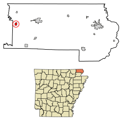 Location of Datto in Clay County, Arkansas. | |
| Coordinates: 36°23′32″N 90°43′46″W / 36.39222°N 90.72944°WCoordinates: 36°23′32″N 90°43′46″W / 36.39222°N 90.72944°W | |
| Country | United States |
| State | Arkansas |
| County | Clay |
| Area[1] | |
| • Total | 0.62 sq mi (1.61 km2) |
| • Land | 0.62 sq mi (1.61 km2) |
| • Water | 0.00 sq mi (0.00 km2) |
| Elevation | 289 ft (88 m) |
| Population (2010) | |
| • Total | 100 |
| • Estimate (2017)[2] | 93 |
| • Density | 149.76/sq mi (57.84/km2) |
| Time zone | UTC-6 (Central (CST)) |
| • Summer (DST) | UTC-5 (CDT) |
| ZIP code | 72424 |
| Area code(s) | 870 |
| FIPS code | 05-17410 |
| GNIS feature ID | 0076749 |
Datto is a town in Clay County, Arkansas, United States. The population was 100 at the 2010 census.[3]
Geography
Datto is located in western Clay County at 36°23′32″N 90°43′46″W / 36.39222°N 90.72944°W (36.392312, -90.729314),[4] about 2 miles (3 km) east of the Current River. U.S. Routes 62 and 67 pass through the town concurrently, leading east 8 miles (13 km) to Corning and west 17 miles (27 km) to Pocahontas.
According to the United States Census Bureau, the town has a total area of 1.7 square miles (4.4 km2), all land.[3]
Demographics
| Historical population | |||
|---|---|---|---|
| Census | Pop. | %± | |
| 1910 | 244 | — | |
| 1920 | 242 | −0.8% | |
| 1930 | 275 | 13.6% | |
| 1940 | 198 | −28.0% | |
| 1950 | 176 | −11.1% | |
| 1960 | 167 | −5.1% | |
| 1970 | 142 | −15.0% | |
| 1980 | 112 | −21.1% | |
| 1990 | 120 | 7.1% | |
| 2000 | 97 | −19.2% | |
| 2010 | 100 | 3.1% | |
| Est. 2017 | 93 | [2] | −7.0% |
| U.S. Decennial Census[5] 2014 Estimate[6] | |||
As of the census[7] of 2000, there were 97 people, 44 households, and 31 families residing in the town. The population density was 54.3/km² (141.1/mi²). There were 53 housing units at an average density of 29.7/km² (77.1/mi²). The racial makeup of the town was 100.00% White. Hispanic or Latino of any race were 1.03% of the population.
There were 44 households out of which 27.3% had children under the age of 18 living with them, 59.1% were married couples living together, 4.5% had a female householder with no husband present, and 29.5% were non-families. 29.5% of all households were made up of individuals and 18.2% had someone living alone who was 65 years of age or older. The average household size was 2.20 and the average family size was 2.71.
In the town, the population was spread out with 21.6% under the age of 18, 6.2% from 18 to 24, 26.8% from 25 to 44, 23.7% from 45 to 64, and 21.6% who were 65 years of age or older. The median age was 44 years. For every 100 females, there were 102.1 males. For every 100 females age 18 and over, there were 105.4 males.
The median income for a household in the town was $28,750, and the median income for a family was $34,375. Males had a median income of $26,250 versus $17,250 for females. The per capita income for the town was $12,790. There were no families and 8.0% of the population living below the poverty line, including no under eighteens and 41.2% of those over 64.
References
- ↑ "2017 U.S. Gazetteer Files". United States Census Bureau. Retrieved Aug 22, 2018.
- 1 2 "Population and Housing Unit Estimates". Retrieved March 24, 2018.
- 1 2 "Geographic Identifiers: 2010 Demographic Profile Data (G001): Datto town, Arkansas". U.S. Census Bureau, American Factfinder. Retrieved June 16, 2014.
- ↑ "US Gazetteer files: 2010, 2000, and 1990". United States Census Bureau. 2011-02-12. Retrieved 2011-04-23.
- ↑ "Census of Population and Housing". Census.gov. Archived from the original on May 12, 2015. Retrieved June 4, 2015.
- ↑ "Annual Estimates of the Resident Population for Incorporated Places: April 1, 2010 to July 1, 2014". Retrieved June 4, 2015.
- ↑ "American FactFinder". United States Census Bureau. Archived from the original on 2013-09-11. Retrieved 2008-01-31.
External links
Municipalities and communities of Clay County, Arkansas, United States | ||
|---|---|---|
| Cities |  | |
| Towns | ||
| Unincorporated communities | ||
| Ghost town | ||
| Footnotes | ‡This populated place also has portions in an adjacent county or counties | |