Klickitat Street
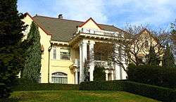 The historic mansion of meatpacking magnate Frank Barnes at number 3533.[1] | |
| Maintained by | City of Portland |
|---|---|
| Length | 3.9 mi[2] (6.3 km) |
| Location | Portland, Oregon |
| West end | Northeast 11th Avenue 45°32′48″N 122°39′18″W / 45.546759°N 122.654874°W |
| East end | Northeast 84th Avenue 45°32′47″N 122°34′36″W / 45.546323°N 122.576776°W |
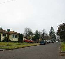
Klickitat Street is a city street located in northeast[3] Portland, Oregon, United States. The main stem of the street is 3.75-mile (6.04 km) long, and runs east-west parallel to—and one block south of—northeast Fremont Street, from the eastern edge of Irving Park to Northeast 67th Avenue.[4] Additional disconnected segments are east of Rocky Butte from 105th to 117th,[5] 148th to 154th,[6] and 163rd to 165th.[7] A segment named Klickitat Court is between 135th and 140th.[8]
The street is one of Portland's most heavily used bicycle throughways and was selected as one of 15 streets slated for improvement as a "next-generation bicycle boulevard" by the city of Portland.[4] Planned improvements included a flashing beacon at the intersection with NE 33rd, which can be enabled by bicyclists and pedestrians to increase safety and maintain low vehicular traffic.[9]
The street is named after a local Native American tribe, the Klickitat, and was made famous because it is the fictional home of the characters Henry Huggins, Ramona Quimby and Beatrice "Beezus" Quimby in a series of children's novels by Beverly Cleary.[10] Cleary grew up on nearby Hancock Street, and said the name reminded her of "the sound of knitting needles."[11] There are statues of the characters in the Beverly Cleary Sculpture Garden in nearby Grant Park.[12]
See also
References
- ↑ Kristine White (Sep 10, 2002), "Living large", The Portland Tribune
- ↑ The Google Maps walking distance is 3.9 miles (6.3 km) according to Google (January 23, 2010). "Klickitat Street" (Map). Google Maps. Google. Retrieved January 23, 2010. , but the actual span is 3.75 miles (6.04 km) due to an unknown cause compared to Google Maps straight line measurement tool.
- ↑ Northeast refers to one of Portland's five quadrants. See Neighborhoods of Portland, Oregon for an overview map.
- 1 2 City of Portland Bureau of Transportation. "Bicycle Boulevards / Neighborhood Greenways: Streets with low traffic volume and speed where bicycles, pedestrians and neighbors are given priority". Portland Online. Retrieved January 23, 2011.
- ↑ Maps of 105th to 117th: 45°32′48″N 122°32′54″W / 45.54679°N 122.54833°W
- ↑ Maps of 148th to 154th: 45°32′50″N 122°30′25″W / 45.54714°N 122.50699°W
- ↑ Maps of 163rd to 165th: 45°32′50″N 122°29′37″W / 45.54712°N 122.49354°W
- ↑ Maps of 135th to 140th: 45°32′48″N 122°31′17″W / 45.54653°N 122.52130°W
- ↑ Anne Laufe (May 28, 2010). "Flashing light to aid Alameda's N.E. 33rd crossing". The Oregonian. Retrieved January 22, 2011.
- ↑ Harriet Baskas (2010), Oregon Curiosities, Globe Pequot, pp. 108–110, ISBN 978-0-7627-4971-3
- ↑ Bumiller, Elisabeth (October 26, 1995). "On Klickitat Street With: Beverly Cleary; For 3 Generations, The Child's Choice". The New York Times. Retrieved January 23, 2011.
- ↑ "Beverly Cleary Sculpture Garden". Multnomah County Library. Archived from the original on June 13, 2010. Retrieved June 1, 2010.
Coordinates: 45°32′49″N 122°36′45″W / 45.546942°N 122.612478°W