Klášter (Plzeň-South District)
| Klášter | |
|---|---|
| Municipality | |
 Klášter | |
| Coordinates: 49°30′0″N 13°34′42″E / 49.50000°N 13.57833°ECoordinates: 49°30′0″N 13°34′42″E / 49.50000°N 13.57833°E | |
| Country |
|
| Region | Plzeň |
| District | Plzeň-South |
| Area | |
| • Total | 8.65 km2 (3.34 sq mi) |
| Elevation | 428 m (1,404 ft) |
| Population (2006) | |
| • Total | 173 |
| • Density | 20/km2 (52/sq mi) |
| Postal code | 335 01 |
| Website | http://www.antee.cz/klaster/ |
Klášter is a village and municipality (obec) in Plzeň-South District in the Plzeň Region of the Czech Republic, about 2 km north of the town Nepomuk. Most of the village is placed inside the ruins of medieval Cistercian monastery (Czech word Klášter means Monastery) which was destroyed in 1420 by Hussite army.
The municipality covers an area of 8.65 square kilometres (3.34 sq mi), and has a population of 173 (as at 28 August 2006).
Klášter lies approximately 32 kilometres (20 mi) south-east of Plzeň and 89 km (55 mi) south-west of Prague.
%2C_kl%C3%A1%C5%A1ter_cisterci%C3%A1k%C5%AF_-_fragmenty.JPG) Remnants of the monastery (probably abbot's house)
Remnants of the monastery (probably abbot's house)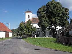 St. Margaret chappel with the remnants of the monastery guest house
References
| Wikimedia Commons has media related to Klášter. |
This article is issued from
Wikipedia.
The text is licensed under Creative Commons - Attribution - Sharealike.
Additional terms may apply for the media files.