Kiskunhalas District
| Kiskunhalas District Kiskunhalasi járás | ||
|---|---|---|
| Districts of Hungary | ||
| ||
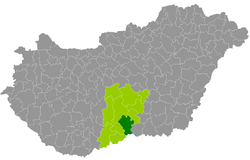 Kiskunhalas District within Hungary and Bács-Kiskun County. | ||
| Country |
| |
| County | Bács-Kiskun | |
| District seat | Kiskunhalas | |
| Area | ||
| • Total | 826.35 km2 (319.06 sq mi) | |
| Area rank | 5th in Bács-Kiskun | |
| Population (2011 census) | ||
| • Total | 43,849 | |
| • Rank | 5th in Bács-Kiskun | |
| • Density | 53/km2 (140/sq mi) | |

Kiskunhalas (Hungarian: Kiskunhalasi járás) is a district in south-eastern part of Bács-Kiskun County. Kiskunhalas is also the name of the town where the district seat is found. The district is located in the Southern Great Plain Statistical Region.
Geography
Kiskunhalas District borders with Kiskunmajsa District to the northeast, Mórahalom District (Csongrád County) to the east, the Serbian district of North Bačka and Bácsalmás District to the south, Jánoshalma District to the west, Kiskőrös District to the northwest. The number of the inhabited places in Kiskunhalas District is 9.
Municipalities
The district has 2 towns and 7 villages. (ordered by population, as of 1 January 2012)[1]
- Balotaszállás (1,497)
- Harkakötöny (934)
- Kelebia (2,583)
- Kiskunhalas (28,427) – district seat
- Kisszállás (2,396)
- Kunfehértó (2,014)
- Pirtó (941)
- Tompa (4,543)
- Zsana (752)
The bolded municipalities are cities.
Demographics
Religion in Kiskunhalas District (2011 census)
In 2011, it had a population of 43,849 and the population density was 53/km².
| Year | County population[2] | Change |
|---|---|---|
| 2011 | 43,849 | n/a |
Ethnicity
Besides the Hungarian majority, the main minorities are the Roma (approx. 1,800), German (500), Serb and Croat (100).
Total population (2011 census): 43,849
Ethnic groups (2011 census):[3] Identified themselves: 41,062 persons:
- Hungarians: 38,161 (92.94%)
- Gypsies: 1,774 (4.32%)
- Germans: 479 (1.17%)
- Others and indefinable: 648 (1.58%)
Approx. 3,000 persons in Kiskunhalas District did not declare their ethnic group at the 2011 census.
Religion
Religious adherence in the county according to 2011 census:[4]
- Catholic – 18,978 (Roman Catholic – 18,910; Greek Catholic – 66);
- Reformed – 3,565;
- Evangelical – 376;
- other religions – 828;
- Non-religious – 8,023;
- Atheism – 419;
- Undeclared – 11,660.
Gallery
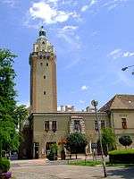 Kiskunhalas, Town Hall
 Boncompagni Mansion in Kisszállás
 Lake in Kunfehértó
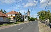 View of Kelebia
See also
References
- ↑ A KSH 2012. évi helységnévkönyve
- ↑ népesség.com, "Kiskunhalasi járás népessége"
- ↑ 4.1.6.1 A népesség nemzetiség szerint, 2011, (in Hungarian)
- ↑ 4.1.7.1 A népesség vallás, felekezet szerint, 2011, (in Hungarian)
External links
| Towns (2) |
| |
|---|---|---|
| Villages (7) | ||