Kalocsa District
| Kalocsa District Kalocsai járás | ||
|---|---|---|
| Districts of Hungary | ||
| ||
 Kalocsa District within Hungary and Bács-Kiskun County. | ||
| Country |
| |
| County | Bács-Kiskun | |
| District seat | Kalocsa | |
| Area | ||
| • Total | 1,062.27 km2 (410.14 sq mi) | |
| Area rank | 3rd in Bács-Kiskun | |
| Population (2011 census) | ||
| • Total | 52,479 | |
| • Rank | 4th in Bács-Kiskun | |
| • Density | 49/km2 (130/sq mi) | |
Kalocsa (Hungarian: Kalocsai járás; German: Kreis Kollotschau) is a district in western part of Bács-Kiskun County. Kalocsa is also the name of the town where the district seat is found. The district is located in the Southern Great Plain Statistical Region.
Geography
Kalocsa District borders with Kunszentmiklós District to the north, Kiskőrös District to the east, Jánoshalma District to the southeast, Baja District to the south, Tolna District and Paks District (Tolna County) to the west. The number of the inhabited places in Kalocsa District is 21.
Municipalities
The district has 3 towns, 2 large villages and 16 villages. (ordered by population, as of 1 January 2013)[1]
- Bátya (2,060)
- Drágszél (326)
- Dunapataj (3,180)
- Dunaszentbenedek (865)
- Dunatetétlen (529)
- Dusnok (2,958)
- Fajsz (1,712)
- Foktő (1,628)
- Géderlak (1,020)
- Hajós (3,115)
- Harta (3,417)
- Homokmégy (1,398)
- Kalocsa (16,552) – district seat
- Miske (1,722)
- Ordas (420)
- Öregcsertő (809)
- Solt (6,488)
- Szakmár (1,237)
- Uszód (1,056)
- Újsolt (181)
- Újtelek (355)
The bolded municipalities are cities, italics municipalities are large villages.
Demographics
Religion in Kalocsa District (2011 census)
In 2011, it had a population of 52,497 and the population density was 49/km².
| Year | County population[2] | Change |
|---|---|---|
| 2011 | 52,497 | n/a |
Ethnicity
Besides Hungarian majority, the main minorities are the German (approx. 3,000), Roma (1,800), Croat (1,000), Slovak and Romanian (100).
Total population (2011 census): 52,497
Ethnic groups (2011 census):[3] Identified themselves: 51,084 persons:
- Hungarians: 44,689 (87.48%)
- Germans: 2,951 (5.78%)
- Gypsies: 1,801 (3.53%)
- Croats: 1,005 (1.97%)
- Others and indefinable: 638 (1.25%)
Approx. 1,500 persons in Kalocsa District did not declare their ethnic group at the 2011 census.
Religion
Religious adherence in the county according to 2011 census:[4]
- Catholic – 25,901 (Roman Catholic – 25,773; Greek Catholic – 121);
- Reformed – 5,957;
- Evangelical – 1,299;
- other religions – 639;
- Non-religious – 5,484;
- Atheism – 379;
- Undeclared – 12,838.
Gallery
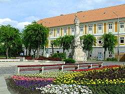 Kalocsa, the district seat
 Fishing lake near Solt
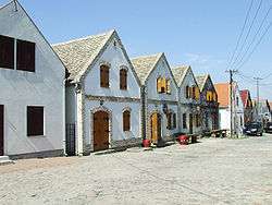 Cellar Village of Hajós
 Assumption Cathedral in Kalocsa
See also
References
- ↑ A KSH 2013. évi helységnévkönyve
- ↑ népesség.com, "Kalocsai járás népessége"
- ↑ 4.1.6.1 A népesség nemzetiség szerint, 2011, (in Hungarian)
- ↑ 4.1.7.1 A népesség vallás, felekezet szerint, 2011, (in Hungarian)
External links
| Towns (3) | ||
|---|---|---|
| Large villages (2) | ||
| Villages (18) | ||