Kisielice
| Kisielice | ||
|---|---|---|
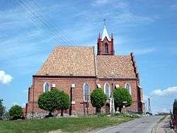 Regina Mundi Church | ||
| ||
 Kisielice | ||
| Coordinates: 53°36′25″N 19°15′34″E / 53.60694°N 19.25944°E | ||
| Country |
| |
| Voivodeship | Warmian-Masurian | |
| County | Iława | |
| Gmina | Kisielice | |
| Area | ||
| • Total | 3.37 km2 (1.30 sq mi) | |
| Population (2006) | ||
| • Total | 2,208 | |
| • Density | 660/km2 (1,700/sq mi) | |
| Postal code | 14-220 | |

Kisielice [kʲiɕɛˈlʲit͡sɛ] (German: Freystadt in Westpreußen) is a town in Warmian-Masurian Voivodeship, Poland, with 2,222 inhabitants (2004).
Geographical location
Kisielice is located on a hill in the vicinity of a small lake in the south of Dolne Powiśle region, approximately 20 km (12 mi) west of Iława, 36 km (22 mi) north-east of Grudziądz, 60 km (37 mi) south of Elbląg, 25 km (16 mi) south-east of Kwidzyn and 80 km (50 mi) south-east of the voivodeship capital of Olsztyn. In the vicinity of the town, there is a 40MW wind farm.
History
The town has been founded in the Old Prussian area formerly settled by the Pomesanians and conquered by the Teutonic Knights until the mid 13th century. First mentioned as Vrienstadt in a 1255 deed, the estates were ceded to the distinguished Stangen noble family by the Bishop of Pomesania in 1293. The bishop vested the settlement with Kulm law and the present-day townscape was laid out from about 1315 onwards. Already in 1331 it held town privileges, was well developed as a community, and had a priest. The town's parish church was built from stone during the first half of the 14th century. A town hall is mentioned in 1406; it has not been rebuilt after it burned down in 1860.
In 1397 Freystadt was repurchased by the Bishop of Pomesania. Upon the Second Peace of Thorn in 1466 it came under the direct rule of the State of the Teutonic Order. Soon after, in 1525, in became part of the newly established Duchy of Prussia under the Hohenzollern duke Albert. The inhabitants of the town acquired their earnings to the most part from professions related to agriculture. In the town lived also a few craftsmen.
From 1818 until 1920 Freystadt belonged to Kreis Rosenberg in the administrative district of Regierungsbezirk Marienwerder in the province of West Prussia, part of Germany from 1871. In 1899 the town was connected to the railway line from Riesenburg (Prabuty) to Jablonowo. In 1928 about 50% of the working people were involved in trade, 20% were workmen, and 13% were civil servants, employees, pensioners and others.
After World War II the remaining German inhabitants of Freystadt, who had not fled prior to the end of war or who had returned, were expelled by Soviet and Polish authorities during subsequent months.
Number of inhabitants by year
| Year | Number | Remarks |
|---|---|---|
| 1576 | 525 | |
| 1782 | 719 | in 134 households (Feuerstellen), mostly Evangelical-Lutheran Germans[1] |
| 1831 | 1,157[2] | |
| 1875 | 2,564[3] | |
| 1880 | 2,298[3] | |
| 1890 | 3,075[3] | |
| 1905 | 2,425 | incl. 2,196 Evangelicals, 71 Catholics and 150 Jews |
| 1933 | 3,075[3] | |
| 1939 | 3,351[3] | |
| 1943 | 3,313 | |
| 2004 | 2,222 |
Notable residents
- Karl Thom (1893-1945), World War I pilot
External links
- Official website (in Polish)
Footnotes
- ↑ Johann Friedrich Goldbeck: Vollständige Topographie des Königreichs Preußen. Teil II, Marienwerder 1789, p. 8, no. 4.
- ↑ August Eduard Preuß: Preußische Landes- und Volkskunde. Königsberg 1835, p. 439, no. 51.
- 1 2 3 4 5 Michael Rademacher: Deutsche Verwaltungsgeschichte Provinz Westpreußen, Kreis Rosenberg (2006).
Coordinates: 53°36′N 19°16′E / 53.600°N 19.267°E