Church Fenton
| Church Fenton | |
|---|---|
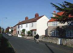 Nanny Lane, Church Fenton | |
 Church Fenton Church Fenton shown within North Yorkshire | |
| Population | 1,392 (2011 census)[1] |
| OS grid reference | SE513368 |
| • London | 150 mi (240 km) SSE |
| Civil parish |
|
| District | |
| Shire county | |
| Region | |
| Country | England |
| Sovereign state | United Kingdom |
| Post town | TADCASTER |
| Postcode district | LS24 |
| Dialling code | 01937 |
| Police | North Yorkshire |
| Fire | North Yorkshire |
| Ambulance | Yorkshire |
| EU Parliament | Yorkshire and the Humber |
| UK Parliament | |
Church Fenton or Kirk Fenton is a village and civil parish in the Selby district of North Yorkshire, England. It is about 16 miles (26 km) east of Leeds, about 6 miles (10 km) south-east from Tadcaster and 3 miles (5 km) north from Sherburn-in-Elmet. Neighbouring villages include Cawood and Ulleskelf. The former RAF Church Fenton is located immediately north-east, which is now known as Leeds East Airport. [2]
History
The name 'Church Fenton' means a village with a church in fen or marshland.[3] The village was recorded along with nearby Little Fenton as Fentun in the Domesday Book of 1086, with no mention of a church. However in 1338 the establishment of church was signified by the name Kirk Fenton.[4] The two names have been variously used to describe either the village or a parish including the hamlets of Little Fenton to the South and Biggin to the South-East.[5] The area was agricultural with some quarry work until the arrival of the Leeds and Selby Railway in 1839, resulting in the development of local industry, including a brickworks and tileworks.[4][6] There was also a gas holder and tank works in the 1920s.[6] Further lines to Harrogate, Leeds and York followed, so that at one point there were three stations. All but one were demolished in the 1990s.[4] A row of terraced houses is called Chicory Row indicating the crop which was grown, boiled and bottled locally at one time.[6]
In 1936 RAF Church Fenton was built as a fighter base and took part in the defence of northern cities and the east coast during the Second World War.Leeds and Selby Railway Later it was used as a pilot training base.[6][4]
It was in the West Riding of Yorkshire,[7] but is now in the county of North Yorkshire.
Amenities
The village has a post office and one public house: The Fenton Flyer, though there were formerly three.[6] The school, Kirk Fenton Parochial Church of England Primary School reflects the name of the parish.[8] Village commuters are served by Church Fenton railway station. The village is also home to a Met Office Weather station.[9]
The studio scenes for the 2016 television series Victoria were filmed in a converted aircraft hangar in Church Fenton.[10]
Buildings
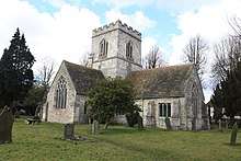
The church of St Mary the Virgin, on Church Street, dates from the 13th century, with a 15th century tower and is one of the smallest cruciform churches in England.[5][7][6] It is a Grade I listed building.[11] The Old Vicarage, on Main Street is also a listed building, Grade II,[12] as is the Village Cross.[13] The church was originally dedicated to St John the Baptist and one of the three bells (18th century) has the figure of St John.[5] It is of Magnesian Limestone with slate roofing.[11] The tower is square with battlements[11] and as well as the bells contains a clock which was installed in 1780.[5] It is fitted with aircraft warning lights because of the nearby aerdrome.[6]
The Methodist church dates from 1892.[4]
Climate
| Climate data for Church Fenton, North Yorkshire 1981–2010 | |||||||||||||
|---|---|---|---|---|---|---|---|---|---|---|---|---|---|
| Month | Jan | Feb | Mar | Apr | May | Jun | Jul | Aug | Sep | Oct | Nov | Dec | Year |
| Average high °C (°F) | 7.0 (44.6) |
7.5 (45.5) |
10.1 (50.2) |
12.6 (54.7) |
16.0 (60.8) |
18.8 (65.8) |
21.2 (70.2) |
20.8 (69.4) |
18.0 (64.4) |
13.9 (57) |
9.9 (49.8) |
7.1 (44.8) |
13.6 (56.4) |
| Average low °C (°F) | 1.0 (33.8) |
0.9 (33.6) |
2.5 (36.5) |
3.8 (38.8) |
6.6 (43.9) |
9.6 (49.3) |
11.8 (53.2) |
11.7 (53.1) |
9.5 (49.1) |
6.7 (44.1) |
3.5 (38.3) |
1.1 (34) |
5.7 (42.3) |
| Average precipitation mm (inches) | 50.3 (1.98) |
37.3 (1.469) |
45.5 (1.791) |
46.3 (1.823) |
42.6 (1.677) |
54.8 (2.157) |
50.2 (1.976) |
57.9 (2.28) |
51.2 (2.016) |
56.7 (2.232) |
53.9 (2.122) |
56.6 (2.228) |
603.3 (23.751) |
| Average precipitation days | 10.8 | 8.5 | 9.9 | 9.0 | 8.9 | 8.9 | 8.6 | 9.4 | 8.3 | 10.1 | 11.0 | 10.6 | 114 |
| Mean monthly sunshine hours | 53.9 | 82.5 | 115.6 | 154.8 | 210.7 | 189.3 | 205.9 | 182.8 | 147.1 | 108.1 | 70.0 | 53.0 | 1,573.7 |
| Source: Met Office[14] | |||||||||||||
References
- ↑ UK Census (2011). "Local Area Report – Church Fenton Parish (1170217395)". Nomis. Office for National Statistics. Retrieved 14 March 2018.
- ↑ "Royal Air Force Church Fenton". rafchurchfenton.org.uk. Retrieved 30 July 2016.
- ↑ List of generic forms in place names in the United Kingdom and Ireland
- 1 2 3 4 5 "About Church Fenton". church-fenton.net. Retrieved 30 July 2018.
- 1 2 3 4 "Tadcaster Benefice". www.stmarystadcaster.co.uk. Retrieved 30 July 2018.
- 1 2 3 4 5 6 7 North Yorkshire Federation of Women's Institutes (1991). North Yorkshire Village Book. Countryside Books. p. 62. ISBN 1 85306 1379.
- 1 2 Mee, Arthur (1941). Yorkshire West Riding. London: Hodder and Stoughton.
- ↑ "Kirk Fenton Parochial CE Primary School". www.kirkfenton.n-yorks.sch.uk. Retrieved 30 July 2018.
- ↑ "Church Fenton last 24 hours weather - Met Office". metoffice.gov.uk. Retrieved 30 July 2016.
- ↑ Behrebs, David (12 September 2016). "How they're turning 'Victoria' TV location into a new airport for Leeds". Yorkshire Post. Retrieved 30 July 2018.
- 1 2 3 Historic England. "Church of St Mary the Virgin (1148436)". National Heritage List for England. Retrieved 30 July 2018.
- ↑ Historic England. "The Old Vicarage (1148437)". National Heritage List for England. Retrieved 30 July 2018.
- ↑ Historic England. "Village Cross (1148435)". National Heritage List for England. Retrieved 30 July 2018.
- ↑ "Church Fenton Climatic Averages 1981-2010". Met Office. Retrieved 22 December 2012.
External links
