Kintigh Generating Station
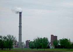
The Kintigh Generating Station, also known as Somerset Operating Co. LLC of the Upstate New York Power Producers[1] is a 675-megawatt coal-fired power plant located in Somerset, New York, United States. The plant was owned by AES Corporation until bankruptcy. Its only currently operating unit was launched into service in 1984.[2] Coal is provided to the plant via the Somerset Railroad. The waste heat is dumped into Lake Ontario, resulting in a warm-water plume visible on satellite images. The plant's smoke stack can be seen across Lake Ontario from the shores of Toronto, Pickering, Oshawa, and Ajax, Ontario. It can also be seen from points along the Niagara Escarpment, including Lockport, NY, approximately 20 miles south. Power from the plant is transferred by 345kV power lines on wood pylons, which run south from the plant through rural agricultural land. In Royalton, NY they connect to a pair of 345kV single-circuit lines called the 345-kV Niagara-to-Edic transmission line, owned by the New York Power Authority, and carried by steel pylons for approximately 200 miles from the Canada–US border at Niagara Falls, NY to a substation near Marcy, NY. The plant is one of only two coal-fired plants remaining in operation in New York. [3]
History
The Somerset Nuclear Power Plant was proposed by New York State Electric & Gas in 1974 as two General Electric 1,200 MW units, but the project was canceled in 1975.[4]
In 1975, NYSEG announced it was changing its construction plans because a geologic fault had been found 40 miles away in Attica.[5] Extra retrofitting costs would have made a nuclear plant infeasible versus a reinforced coal . A 650 MW coal plant was built at the site and went into service in 1984 ahead of schedule and under budget.[6][7]
In 2012, the plant was sold to Upstate New York Power Producers.[8]
Environmental Impacts
In 2010, the Clean Air Task Force, a nonprofit research and advocacy association, published a report evaluating the environmental and health effects attributable to fine particle pollution from coal-fired U.S. power plants, specifically mentioning the Kintigh Generating Station.[9] The report focused on air pollution from soot, heavy metals, sulfur dioxide and nitrogen oxides. Alleging that fine particle pollution from coal power plants is responsible for 13,000 deaths annually in the United States, it posited that the Kintigh Generating Station's fine particle pollution caused 11 preventable deaths a year, 19 heart attacks and 170 asthma attacks.[10] The Research and Policy Center of Environment New York has also been critical of the Kintigh Generating Station, claiming in 2011 that the plant emits almost 3.8 million mass tons of the greenhouse gas carbon dioxide each year.[11]
References
- ↑ Wolcott, Bill (2012-08-26). "AES out at Somerset plant, facility now run by Upstate Power".
- ↑ "Existing Electric Generating Units in the United States, 2006" (Excel). Energy Information Administration, U.S. Department of Energy. 2006. Retrieved 2008-07-14.
- ↑ "Last coal cars roll into Kodak Park, making final delivery as power plant converts to gas". Rochester Democrat and Chronicle. Retrieved 2018-03-14.
- ↑ Nuclear Power Generation and Fuel Cycle Report 1997 Archived 2009-10-09 at the Wayback Machine. p. 67.
- ↑ "Geological Fault Causes Con Edison To Drop A-Plant". The New York Times. July 26, 1975. A later correction mentions that the title should have read NYSEG.
- ↑ Electricity Resource Assessment
- ↑ Coal Plant on Schedule, Below Costs
- ↑ Wolcott, Bill (2012-08-26). "AES out at Somerset plant, facility now run by Upstate Power".
- ↑ Conrad Schneider and Jonathan Banks. "The Toll From Coal" (PDF). Catf.us. Retrieved 31 July 2018.
- ↑ "Death and Disease from Power Plants". Catf.us. Clear Air Task Force. Retrieved 31 July 2018.
- ↑ Flanagan, Jenna (17 September 2013). "America's dirtiest power plants: five are in New York". North Country Public Radio. Retrieved 31 July 2018.
External links
Coordinates: 43°21′29″N 78°36′14″W / 43.35806°N 78.60389°W