Kington Langley
| Kington Langley | |
|---|---|
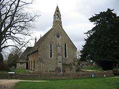 St Peter's parish church, Middle Common | |
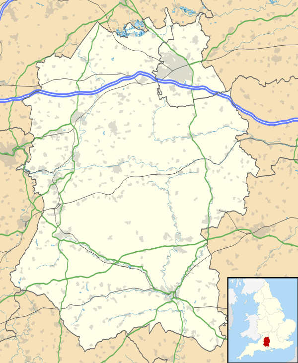 Kington Langley Kington Langley shown within Wiltshire | |
| Population | 841 (in 2011)[1] |
| OS grid reference | ST926770 |
| Unitary authority | |
| Ceremonial county | |
| Region | |
| Country | England |
| Sovereign state | United Kingdom |
| Post town | Chippenham |
| Postcode district | SN15 |
| Dialling code | 01249 |
| Police | Wiltshire |
| Fire | Dorset and Wiltshire |
| Ambulance | South Western |
| EU Parliament | South West England |
| UK Parliament | |
| Website |
www |
Kington Langley is a village and civil parish about 2 miles (3.2 km) north of Chippenham in Wiltshire, England.[2] The parish includes the hamlet of Bowldown.
Geography
The parish covers about 1,571 acres (636 ha). The geology is mostly of the Jurassic and Cretaceous periods. It is on a high water table and the soil is composed of sand with a sub-soil of Oxford Clay. The village stands on a hill, rising to 100 metres (330 ft) towards its western end. It is an example of a 'squared' village with approaches from Chippenham, Swindon and Malmesbury. It has three greens; the largest is the Common, which covers 30 acres (12 ha) and is the focal point of the village.
The village is 1.5 miles (2.4 km) long and is separated from Kington St. Michael (to the west) by the A350 road which links Chippenham with the M4 motorway and Malmesbury.
Governance
Kington Langley is in the area of Wiltshire Council unitary authority, which performs most local government functions.
The parish is part of Kington electoral ward which covers seven rural parishes north of Chippenham, together with Chippenham Without to the west. The population of the ward at the 2011 census was 5,014.[3]
History
A settlement of 25 households at Langhelei was recorded in the Domesday Book of 1068, when the land was held by Glastonbury Abbey.[4]
Kington Langley was part of the parish of Kington St. Michael until 1865. The Kington prefix serves to distinguish it from another nearby village, Langley Burrell. The hamlet was known as Langley Fitzurze in medieval times, although other spellings such as Langeleghe (11th century), "Langley Fearne" (c.1513), "Langley Fernhill" (1660) have been used.[5]
The Greathouse, beside the B4069 road, was built in about 1700. It is a country house of nine bays and two storeys.[6] It became a farmhouse until it was restored and extended in 1910, and is now a Leonard Cheshire home. The house was designated as Grade II* listed in 1960.[7]
A National School was built in 1856/7 for 50-60 children and enlarged in 1886; by 1919 there were around 90 pupils. Children of all ages attended until 1940 when those over 11 went to secondary schools in Chippenham.[8]
Churches
Parish church
Parishioners used to have to travel more than 1 mile (1.6 km) from Kington Langley to worship at Kington St. Michael. In the 1670s a chapel of ease was created by converting a cottage at Kington Langley.[9] In 1857[10] a purpose-built chapel of ease was completed, which was made the Church of England parish church of Saint Peter in 1865.[9] The building was designed by C.H. Gabriel with lancet windows in an Early English Gothic style.[6] St. Peter's is in the Diocese of Bristol.
Since 1954 the vicar of Kington Langley also served the former parish of Draycot Cerne, which lost its church in 1994 when St James' was declared redundant. Today the parish is part of the Draycot benefice, which covers five neighbouring parishes.[11]
Union Chapel
The earliest known record of Protestant Dissenters meeting for worship in Kington Langley is dated 1742. They met in private houses until 1834, when the house registered for their meetings was that of James Pinnegar, a builder. Pinnegar built Union Chapel on the Common, completing it in 1835.[6] The name refers to its foundation as a union of Dissenters of the Baptist, Moravian and Independent traditions.[12]
The chapel choir met in the middle of the nineteenth century at a chapel-goer's house on Sundays. The chapel also had a band that used instruments such as flutes and violas.
Union Chapel remains independent, and as of 2015 is active under the title of Union Chapel Christian Fellowship.[13]
Amenities
Kington Langley has two public houses: the Hit or Miss Inn (17th century)[14] and the Plough Inn (17th and 18th).[15] The primary school continues as Langley Fitzurse CofE Primary School, with voluntary controlled status. There is a village hall, a playing field, a tennis court and a park.
Notable people
- Harry Dolman (1897–1977), chairman and president of Bristol City F.C.
- Norris McWhirter (1925–2004), editor of Guinness World Records
- Robin Tanner (1904–1988), artist
- Heather Tanner (1903–1993), writer and campaigner
Wiltshire Village, a 1939 book published by Collins with text by Heather Tanner and illustrations by her husband Robin, is a thinly disguised description of local village life.
References
- ↑ "Wiltshire Community History – Census". Wiltshire Council. Retrieved 17 February 2015.
- ↑ OS Explorer Map 156, Chippenham and Bradford-on-Avon Scale: 1:25 000; publisher: Ordnance Survey A2 edition (2007). ISBN 978-0319239438
- ↑ "Kington ward 2011". Retrieved 12 March 2015.
- ↑ (Kington) Langley in the Domesday Book
- ↑ "Kington Langley". Wiltshire Community History. Wiltshire Council. Retrieved 17 February 2015.
- 1 2 3 Pevsner & Cherry, 1975, page 281
- ↑ Historic England. "The Greathouse (1022321)". National Heritage List for England. Retrieved 1 December 2017.
- ↑ "Langley Fitzurse Church of England Primary School". Wiltshire Community History. Wiltshire Council. Retrieved 1 December 2017.
- 1 2 Temple-Fry, Nick (April 2010). "Kington Langley St Peter's". theChurchPhotographer. Nick Temple-Fry. Retrieved 18 June 2010.
- ↑ Historic England. "Church of Saint Peter (1283658)". National Heritage List for England. Retrieved 30 November 2017.
- ↑ "St Peter's - Kington Langley". Draycot Benefice. Retrieved 30 November 2017.
- ↑ "Union Chapel, Kington Langley". Wiltshire Community History. Wiltshire Council. Retrieved 17 February 2015.
- ↑ "Union Chapel". Kington Langley Parish Council. Retrieved 17 February 2015.
- ↑ Historic England. "The Hit or Miss Inn (1283664)". National Heritage List for England. Retrieved 1 December 2017.
- ↑ Historic England. "The Plough Inn (1283620)". National Heritage List for England. Retrieved 1 December 2017.
Sources
- Pevsner, Nikolaus; Cherry, Bridget (revision) (1975) [1963]. The Buildings of England: Wiltshire. Harmondsworth: Penguin Books. p. 281.
External links
![]()