Kingsmead, Bath
| Kingsmead | |
|---|---|
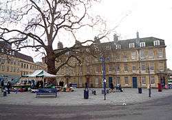
.jpg) New King Street, in the east of the ward | |
 Kingsmead Kingsmead shown within Somerset | |
| Population | 5,516 (ward, 2011)[1] |
| OS grid reference | ST740653 |
| Unitary authority | |
| Ceremonial county | |
| Region | |
| Country | England |
| Sovereign state | United Kingdom |
| Post town | BATH |
| Postcode district | BA1 |
| Dialling code | 01225 |
| Police | Avon and Somerset |
| Fire | Avon |
| Ambulance | South Western |
| EU Parliament | South West England |
| UK Parliament | |
Kingsmead is a largely residential electoral ward within Bath, England.
Kingsmead is rarely used as the name of an area of Bath, and is primarily used for electoral purposes within the Bath and North East Somerset unitary authority, electing two councillors.[2] Kingsmead stretches about 1 mile (1.6 km) westward from the western edge of the city centre, straddling the A4 road north of the River Avon. The ward is separated by the large Royal Victoria Park into a near city centre eastern end, and a western residential end known as Lower Weston.[3]
St Andrew's Church of England Primary School is located in the northeast corner of the ward.[4]
Residents in the western end of the ward often use the facilities, such as schools, of the neighbouring Newbridge and Weston wards, and associate themselves with these localities. The Chelsea Road shopping area is part of the ward's western boundary so half of these shops are within Kingsmead ward. The eastern industrial units of Locksbrook are also within the ward.[3]
The closed Mangotsfield and Bath Branch Line formerly ran through the ward from Green Park station, now a shopping area, through Weston station in the west of the ward. The Bristol & Bath Railway Path runs through the ward, but on the River Avon path rather than the former railway track which has been developed upon within the city.
The electoral wards surrounding the ward are: Newbridge to the west, Weston and Lansdown to the north, Abbey to the east, and Widcombe and Westmoreland to the south over the River Avon.[3]
Notable places
Notable places within the ward, from east to west, are:
References
- ↑ "Ward population 2011". Retrieved 7 April 2015.
- ↑ "The Avon (Structural Change) Order 1995". legislation.gov.uk. The National Archives. Retrieved 19 March 2011.
- 1 2 3 "Kingsmead Ward (map)" (PDF). Bath & North East Somerset Council. Retrieved 7 June 2016.
- ↑ "St Andrew's Church of England Primary School". St Andrew's Church of England Primary School. Retrieved 10 March 2011.
External links
- Ward Profile - Kingsmead, Bath and North East Somerset