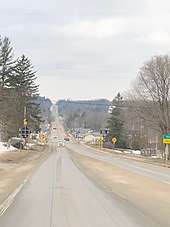
Kingsley, Michigan
| Kingsley, Michigan | ||
|---|---|---|
| Village | ||
| Village of Kingsley | ||
| ||
 Location of Kingsley, Michigan | ||
| Coordinates: 44°35′3″N 85°32′14″W / 44.58417°N 85.53722°WCoordinates: 44°35′3″N 85°32′14″W / 44.58417°N 85.53722°W | ||
| Country | United States | |
| State | Michigan | |
| County | Grand Traverse | |
| Government | ||
| • President | Rodney Bogart | |
| Area[1] | ||
| • Total | 1.44 sq mi (3.73 km2) | |
| • Land | 1.42 sq mi (3.68 km2) | |
| • Water | 0.02 sq mi (0.05 km2) | |
| Elevation | 968 ft (295 m) | |
| Population (2010)[2] | ||
| • Total | 1,480 | |
| • Estimate (2016)[3] | 1,567 | |
| • Density | 1,000/sq mi (400/km2) | |
| Time zone | UTC-5 (Eastern (EST)) | |
| • Summer (DST) | UTC-4 (EDT) | |
| ZIP code | 49649 | |
| Area code(s) | 231 | |
| FIPS code | 26-43340[4] | |
| GNIS feature ID | 0629725[5] | |
| Website |
www | |

Kingsley is a rural village in Paradise Township, Grand Traverse County in the U.S. state of Michigan. The population was 1,480 at the 2010 census.
Geography
According to the United States Census Bureau, the village has a total area of 1.44 square miles (3.73 km2), of which 1.42 square miles (3.68 km2) is land and 0.02 square miles (0.05 km2) is water.[1] The Kingsley ZIP code, 49649, serves the majority of Paradise Township, as well as the southwest corner of Union Township, the western portion of Fife Lake Township, a portion of northern Greenwood Township, the northeast corner of Hanover Township, a large portion of western Mayfield Township, and the southwest corner of Blair Township.[6]
Government
The village president of Kingsley is Rodney Bogart. The president pro tempore is Dan Walton. The five village trustees are Chris McPherson, Nate Alger, Eric Weger, Jason Hamilton, and Jim King.[7]
Demographics
| Historical population | |||
|---|---|---|---|
| Census | Pop. | %± | |
| 1900 | 419 | — | |
| 1910 | 497 | 18.6% | |
| 1920 | 350 | −29.6% | |
| 1930 | 302 | −13.7% | |
| 1940 | 385 | 27.5% | |
| 1950 | 425 | 10.4% | |
| 1960 | 586 | 37.9% | |
| 1970 | 632 | 7.8% | |
| 1980 | 664 | 5.1% | |
| 1990 | 738 | 11.1% | |
| 2000 | 1,469 | 99.1% | |
| 2010 | 1,480 | 0.7% | |
| Est. 2016 | 1,567 | [3] | 5.9% |
| U.S. Decennial Census[8] | |||
2010 census
As of the census[2] of 2010, there were 1,480 people, 519 households, and 380 families residing in the village. The population density was 1,042.3 inhabitants per square mile (402.4/km2). There were 568 housing units at an average density of 400.0 per square mile (154.4/km2). The racial makeup of the village was 95.6% White, 0.7% African American, 1.1% Native American, 0.1% Asian, 0.2% Pacific Islander, 0.1% from other races, and 2.2% from two or more races. Hispanic or Latino of any race were 2.4% of the population.
There were 519 households of which 45.3% had children under the age of 18 living with them, 48.7% were married couples living together, 17.1% had a female householder with no husband present, 7.3% had a male householder with no wife present, and 26.8% were non-families. 21.4% of all households were made up of individuals and 8.1% had someone living alone who was 65 years of age or older. The average household size was 2.83 and the average family size was 3.26.
The median age in the village was 32.6 years. 31.4% of residents were under the age of 18; 9.2% were between the ages of 18 and 24; 27.7% were from 25 to 44; 22.1% were from 45 to 64; and 9.5% were 65 years of age or older. The gender makeup of the village was 48.1% male and 51.9% female.
2000 census
As of the census[4] of 2000, there were 1,469 people, 501 households, and 375 families residing in the village. The population density was 1,324.8 per square mile (511.0/km²). There were 524 housing units at an average density of 472.6 per square mile (182.3/km²). The racial makeup of the village was 97.28% White, 0.27% African American, 0.82% Native American, 0.75% from other races, and 0.88% from two or more races. Hispanic or Latino of any race were 1.77% of the population.
There were 501 households out of which 47.5% had children under the age of 18 living with them, 56.3% were married couples living together, 15.0% had a female householder with no husband present, and 25.1% were non-families. 19.0% of all households were made up of individuals and 6.6% had someone living alone who was 65 years of age or older. The average household size was 2.90 and the average family size was 3.31.
In the village, the population was spread out with 33.9% under the age of 18, 9.9% from 18 to 24, 33.6% from 25 to 44, 15.5% from 45 to 64, and 7.1% who were 65 years of age or older. The median age was 28 years. For every 100 females, there were 88.1 males. For every 100 females age 18 and over, there were 90.4 males.
The median income for a household in the village was $40,229, and the median income for a family was undetermined. Males had a median income of more than females. The per capita income for the village was $16,508. About 17.3% of the population were below the poverty line.
Transportation
Roadways


- Garfield Road and Summit City Road (CR 611), a major north–south county road providing direct service between Kingsley and Traverse City.
- Indian Trails bus service runs through the town.
Air travel
- Cherry Capital Airport is a major nearby airport in Traverse City, providing year-round access to Chicago and Detroit.
- Green Lake Airport is a small nearby private airport.
References
- 1 2 "US Gazetteer files 2010". United States Census Bureau. Archived from the original on July 14, 2012. Retrieved November 25, 2012.
- 1 2 "American FactFinder". United States Census Bureau. Retrieved November 25, 2012.
- 1 2 "Population and Housing Unit Estimates". Retrieved June 9, 2017.
- 1 2 "American FactFinder". United States Census Bureau. Retrieved January 31, 2008.
- ↑ "US Board on Geographic Names". United States Geological Survey. October 25, 2007. Retrieved January 31, 2008.
- ↑ "49649 5-Digit ZCTA, 496 3-Digit ZCTA - Reference Map". American FactFinder. United States Census Bureau. 2000.
- ↑ "Village Council - Village of Kingsley, Michigan". www.villageofkingsley.com. Retrieved 2018-04-18.
- ↑ "Census of Population and Housing". United States Census Bureau. Archived from the original on May 12, 2015. Retrieved June 4, 2015.
Municipalities and communities of Grand Traverse County, Michigan, United States | ||
|---|---|---|
| City | 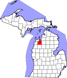 | |
| Villages | ||
| Charter townships | ||
| General law townships | ||
| CDPs | ||
| Other unincorporated communities | ||
| Indian reservation | ||
| Footnotes | ‡This populated place also has portions in an adjacent county or counties | |