Grawn, Michigan
| Grawn, Michigan | |
|---|---|
| Census-designated place | |
| Coordinates: 44°39′45″N 85°41′36″W / 44.66250°N 85.69333°WCoordinates: 44°39′45″N 85°41′36″W / 44.66250°N 85.69333°W[1] | |
| Country | United States |
| State | Michigan |
| County | Grand Traverse |
| Township | Blair |
| Area[2] | |
| • Total | 0.63 sq mi (1.64 km2) |
| • Land | 0.63 sq mi (1.64 km2) |
| • Water | 0.0 sq mi (0.0 km2) |
| Elevation[1] | 889 ft (271 m) |
| Population (2010)[2] | |
| • Total | 772 |
| • Density | 1,200/sq mi (470/km2) |
| Time zone | UTC-5 (Eastern (EST)) |
| • Summer (DST) | UTC-4 (EDT) |
| ZIP code | 49637 |
| Area code | 231 |
| GNIS feature ID | 627256[1] |
| FIPS code | 26-34620 |

Grawn is an unincorporated community and census-designated place (CDP) in Blair Township, Grand Traverse County, Michigan, United States, where U.S. Route 31, West Silver Lake Road, and County Road 633 meet. As of the 2010 census it had a population of 772.[2]
Via US 31, it is 9 miles (14 km) northeast to Traverse City, the county seat, and 22 miles (35 km) west to Beulah.
References
- 1 2 3 "Chums Corner". Geographic Names Information System. United States Geological Survey.
- 1 2 3 "Geographic Identifiers: 2010 Demographic Profile Data (G001): Grawn CDP, Michigan". American Factfinder. U.S. Census Bureau. Retrieved December 19, 2016.
External links
Municipalities and communities of Grand Traverse County, Michigan, United States | ||
|---|---|---|
| City | 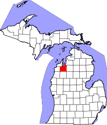 | |
| Villages | ||
| Charter townships | ||
| General law townships | ||
| CDPs | ||
| Other unincorporated communities | ||
| Indian reservation | ||
| Footnotes | ‡This populated place also has portions in an adjacent county or counties | |
This article is issued from
Wikipedia.
The text is licensed under Creative Commons - Attribution - Sharealike.
Additional terms may apply for the media files.