King Edward Cove
| King Edward Cove | |
|---|---|
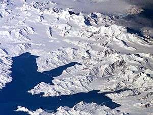 Central South Georgia: Cumberland Bay; Thatcher Peninsula with King Edward Cove (Grytviken); Allardyce Range with the summit Mount Paget (NASA imagery). | |
 King Edward Cove  King Edward Cove | |
| Coordinates | 54°17′S 36°30′W / 54.283°S 36.500°W |
King Edward Cove is a sheltered cove immediately southwest of Mount Duse, in the west side of Cumberland East Bay, South Georgia. This cove, frequented by early sealers at South Georgia, was charted by the Swedish Antarctic Expedition, 1901–04, under Otto Nordenskiöld. It was named in about 1906 for King Edward VII of the United Kingdom.[1]
Just 0.25 miles (0.4 km) south of the entrance is Susa Point, a low rocky point marking the seaward end of a small east-west ridge separating two tussock-covered flats. Like the cove, it was first surveyed by the Swedish Antarctic Expedition under Nordenskjold. It was later named by the Falkland Islands Dependencies Survey (FIDS) following their sketch survey in 1951. The name is one of a group in the vicinity of Discovery Point derived from the chemical fixatives used there in biological work by the FIDS.[2]
References
- ↑ "King Edward Cove". Geographic Names Information System. United States Geological Survey. Retrieved 2013-05-02.
- ↑ "Susa Point". Geographic Names Information System. United States Geological Survey. Retrieved 2018-08-27.
![]()