Cumberland East Bay
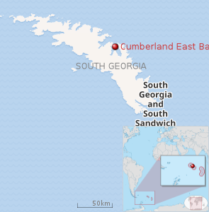 |
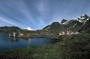
Cumberland East Bay is a bay forming the eastern arm of Cumberland Bay, South Georgia. It is entered between Sappho Point and Barff Point, where it is nearly 3 miles (4.8 km) wide, and extends 8 miles (13 km) in a southeast direction. This feature was surveyed by the Swedish Antarctic Expedition, 1901–04, who named it "South Bay". It was remapped during 1926–29 by Discovery Investigations personnel and renamed "East Cumberland Bay", which is more descriptive of its geographic position. The shortened form "East Bay" was simultaneously used. Following the South Georgia Survey, 1951–52, the UK Antarctic Place-Names Committee proposed that the name be altered to Cumberland East Bay and that all other names be rejected. This change brings together information about the whole of Cumberland Bay in one place in indexes, and will avoid confusion with East Bay in Prince Olav Harbour, South Georgia.
On 22 April – 24 April, 1982, during the Falklands War, the British Special Boat Service attempted to cross Cumberland East Bay. They had landed in Hound Bay, and traversed the Sörling Valley, but were prevented from attacking Argentine positions by incessant ice and snow.[1]
See also
References
