Belkofski, Alaska
Belkofoski is a small unincorporated community in the Aleutians East Borough in Alaska.
Location
Belkofski is on a point at the eastern end of the Alaska Peninsula, 12 miles southeast of King Cove.
History
Russians originally settled Aleuts at Belkofski in 1823 to harvest sea otters in the area; at its height, it was the area's most important village. In the 1880s, three stores were constructed, which were stocked with goods from San Francisco. There was a Russian Orthodox Holy Resurrection church built at that time as well. When the sea otter population diminished, so did the population. The economy switched to trapping wild game, and many people moved to the neighboring communities of Sand Point, Alaska and King Cove attracted the population away from the village. The last people left for King Cove in the 1980s; they brought everything with them and established a new Orthodox church there.
Demographics
| Historical population | |||
|---|---|---|---|
| Census | Pop. | %± | |
| 1880 | 268 | — | |
| 1890 | 185 | −31.0% | |
| 1900 | 147 | −20.5% | |
| 1920 | 129 | — | |
| 1930 | 123 | −4.7% | |
| 1940 | 140 | 13.8% | |
| 1950 | 119 | −15.0% | |
| 1960 | 57 | −52.1% | |
| 1970 | 59 | 3.5% | |
| 1980 | 10 | −83.1% | |
| 1990 | 0 | −100.0% | |
| 2000 | 0 | — | |
| 2010 | 0 | — | |
| U.S. Decennial Census[1] | |||
Belkofski first appeared on the 1880 U.S. Census as the unincorporated village of Belkovsky with 268 residents (making it the 25th largest community in the Alaska Territory).[2] It appeared as "Belkovsky" in 1890, as Belkofski Village in 1900, it did not report in 1910, and as Belkofski from 1920-1970, with the exception of 1940 when it was erroneously reported as "Balkofski." Beginning in 1980, it was classified as an "Alaska Native Village" and from 1990 through 2010 censuses as an Alaska Native Village Statistical Area (ANVSA), but on the last three censuses has reported a population of zero.
Climate
The area is in a maritime climate zone. Temperatures range from −13 to 78 °F (−25 to 26 °C). Average snowfall is 56 inches (1,400 mm), with an annual precipitation of 33 inches (840 mm) a year.
Elevation
Generally 85 feet (26 m) above sea level.
References
- ↑ "U.S. Decennial Census". Census.gov. Retrieved June 6, 2013.
- ↑ http://www2.census.gov/prod2/decennial/documents/1880a_v1-17.pdf
External links
Municipalities and communities of Aleutians East Borough, Alaska, United States | ||
|---|---|---|
| Cities | 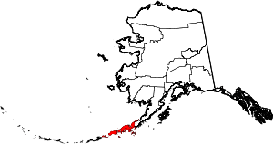 | |
| CDP | ||
| Unincorporated communities | ||
| Ghost towns | ||
Coordinates: 55°05′20″N 162°01′50″W / 55.08889°N 162.03056°W