Kildrummy Castle
| Kildrummy Castle | |
|---|---|
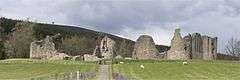 Kildrummy Castle | |
 Location of Kildrummy Castle in Aberdeenshire | |
| General information | |
| Country | Scotland |
| Coordinates | 57°14′05″N 2°54′17″W / 57.234811°N 2.904631°W |
| Completed | 13th century |
| Owner | Historic Scotland |
Kildrummy Castle is a ruined castle near Kildrummy, in Aberdeenshire, Scotland. Though ruined, it is one of the most extensive castles dating from the 13th century to survive in eastern Scotland, and was the seat of the Earls of Mar. It is owned today by Historic Scotland and is open to the public as a scheduled ancient monument.[1]
History
The castle was probably built in the mid-13th century under Gilbert de Moravia. It has been posited that siting of Kildrummy Castle was influenced by the location of the Grampian Mounth trackway crossings, particularly the Elsick Mounth and Cryne Corse Mounth.[2] Kildrummy Castle underwent siege numerous times in its history, first in defence of the family of Robert the Bruce in August–September 1306 (leading to the executions of Nigel Bruce and many other Scots),[3] and again in 1335 by David of Strathbogie. On this occasion Christina Bruce held off the attackers until her husband Sir Andrew Murray came to her rescue.[4] In the reign of David II, Walter Maule of Panmure was warden of Kildrummy Castle.[5]
In 1374 the castle's heiress Isobel was seized and married by Alexander Stewart, who then laid claim to Kildrummy and the title of Earl of Mar. In 1435 it was taken over by James I, becoming a royal castle until being granted to Lord Elphinstone in 1507.
The castle passed from the Clan Elphinstone to the Clan Erskine before being abandoned in 1716 following the failure of the Jacobite rebellion of 1715.
Architecture
Kildrummy Castle is "shield-shaped" in plan with a number of independent towers. The flat side of the castle overlooks a steep ravine; moreover, on the opposite side of the castle the walls come to a point, which was once defended by a massive twin-towered gatehouse. The castle also had a keep, called the Snow Tower, taller than the other towers, built in the French style, as at Bothwell Castle. Extensive earthworks protected the castle, including a dry moat and the ravine. Most of the castle foundations are now visible, along with most of its lower-storey walls. Archaeological excavations in 1925 uncovered decorative stone flooring and evidence of battles.
Today
The castle was given into the care of the Ministry of Works in 1951,[6] and is now owned by its successor organisation, Historic Scotland. Kildrummy Castle gardens, in the quarry used to excavate stone for the castle, are both open to the public.[7][8][9]
A hotel (the Kildrummy Castle Hotel) has been built on the old estate, overlooking the ruins.
Kildrummy Castle was the venue for the Scottish Sculpture Open, sometimes known as the Kildrummy Open, organised by the Scottish Sculpture Workshop from 1981 to 1997.[10]
References
- ↑ "Kildrummy Castle – SM90181". Historic Environment Scotland. Retrieved 9 September 2017.
- ↑ C. Michael Hogan, Elsick Mounth, Megalithic Portal, ed A. Burnham
- ↑ The Life of Robert Bruce, King of Scotland. Edinburgh. 1810. p. 39. Retrieved 14 January 2017.
- ↑ Ormrod, W. M. (2011). Edward III (Online ed.). New Haven: Yale UP. Retrieved 14 January 2017.
- ↑ Maule, Harry (1874). Stuart, John, ed. Registrum de Panmure. Records of the families of Maule, De Valoniis, Brechin, and Brechin-Barclay, united in the line of the Barons and Earls of Panmure. Edinburgh: Fox Maule-Ramsay{{inconsistent citations}}
- ↑ Apted, M. R. (1965). "Excavation at Kildrummy Castle, Aberdeenshire, 1952–62" (PDF). Proceedings of the Society of Antiquaries of Scotland. 96: 208&ndash, 236. doi:10.5284/1000184.
- ↑ "Kildrummy Castle". Places to visit. Historic Scotland. Retrieved 11 July 2012.
- ↑ "Kildrummy Castle Gardens". Scotland's Gardens Scheme. Archived from the original on 22 January 2012. Retrieved 11 July 2012.
- ↑ "Kildrummy Castle Gardens website". Archived from the original on 24 July 2012. Retrieved 11 July 2012.
- ↑ http://www.ssw.org.uk
External links
| Wikimedia Commons has media related to Kildrummy Castle. |
Settlements and places of interest in Marr, Aberdeenshire | ||
|---|---|---|
| Primary settlements | 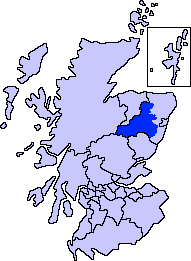 | |
| Other settlements | ||
| Places of interest |
| |
Coordinates: 57°14′5.32″N 2°54′16.67″W / 57.2348111°N 2.9046306°W