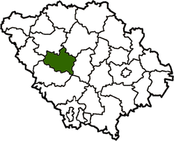
Khorol Raion
| Khorol Raion Хорольський район | |||
|---|---|---|---|
| Raion | |||
| |||
 | |||
| Coordinates: 49°47′5.2254″N 33°15′54.327″E / 49.784784833°N 33.26509083°ECoordinates: 49°47′5.2254″N 33°15′54.327″E / 49.784784833°N 33.26509083°E | |||
| Country |
| ||
| Region | Poltava Oblast | ||
| Established | March 7, 1923 | ||
| Admin. center | Khorol | ||
| Subdivisions |
List
| ||
| Government | |||
| • Governor | Vitaliy Shevshuga | ||
| Area | |||
| • Total | 1,062 km2 (410 sq mi) | ||
| Population | |||
| • Total | 34,558 | ||
| • Density | 33/km2 (84/sq mi) | ||
| Time zone | UTC+2 (EET) | ||
| • Summer (DST) | UTC+3 (EEST) | ||
| Postal index | 37800—37874 | ||
| Area code | +380-5362 | ||
| Website | Official homepage | ||

Khorol Raion (Ukrainian: Хорольський район) is a raion (district) in Poltava Oblast in central Ukraine. The raion's administrative center is the town of Khorol. Population: 34,558 (2015 est.)[1]
Gallery
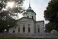 Trinity Church in Vyshniaky, Khorol district
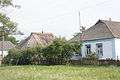 Old buildings in Vyshniaky, Khorol district
References
- ↑ "Чисельність наявного населення України (Actual population of Ukraine)" (PDF) (in Ukrainian). State Statistics Service of Ukraine. Retrieved 1 July 2016.
| Raions | |||||
|---|---|---|---|---|---|
| Cities |
| ||||
| |||||
This article is issued from
Wikipedia.
The text is licensed under Creative Commons - Attribution - Sharealike.
Additional terms may apply for the media files.