Khawr al Udayd
| Khawr al Udayd خور العديد | |
|---|---|
| Settlement | |
 Khawr al Udayd | |
| Coordinates: 24°37′48″N 51°17′46″E / 24.630°N 51.296°ECoordinates: 24°37′48″N 51°17′46″E / 24.630°N 51.296°E | |
| Country | Qatar |
| Municipality | Al Wakrah Municipality |
| Area | |
| • Total | 705 km2 (272 sq mi) |
| Population (2015) | |
| • Total | 7 |
| • Density | 0.0099/km2 (0.026/sq mi) |
Khawr al Udayd, (Arabic: خور العديد; also spelled Khor al Adaid and Khor al-‘Udeid) is a settlement and inlet of the Persian Gulf located in Al Wakrah Municipality in southeast Qatar, on the border with Saudi Arabia. It is known to local English speakers as the "Inland Sea".
The area was declared a nature reserve in 2007.[1]
History

The area of Khawr al Udayd had been a point of friction between Qatar and what is now Saudi Arabia and the United Arab Emirates (UAE).[2] Khawr al Udayd had served as a refuge for pirates from the Emirate of Abu Dhabi (now part of the UAE) during the 19th century. Members of the Bani Yas tribe migrated and settled in the area on two separate occasions: 1835 and 1849.[3] One of the more notable settlers in 1835 was the pirate Jasim bin Jabir, who was joined there by his crew. The residents of eastern Qatar abetted the pirates of Khawr al Udayd in their pillaging of vessels off the coast of Abu Dhabi, resulting in a British naval force being sent to the settlement in 1836 to accost the piratical acts. The British ordered the chiefs of major Qatari towns to immediately desist from sending supplies to the pirates and instructed them to seize the pirate's boats.[4] Additionally, the British naval force set fire to one of the pirate's vessels. As a result, Jassim bin Jabir relocated to Doha in September 1836.[5] After receiving approval from the British in May 1837, the ruler of Abu Dhabi sent his troops to sack the settlement at Khawr al Udayd; 50 of its inhabitants were killed and its houses and fortifications were dismantled during the event.[6]
In the mid-1800s, the settlement at Khawr al Udayd was inhabited by approximately 200 Bani Yas tribesmen who owned a total 30 pearling ships. The area was well protected, containing a small fort with two towers in the center of the town.[3]
In 1878, the British and the Abu Dhabi government concocted a plan to invade Khawr al Udayd in order to curtail the piracy of its inhabitants. In response, Jassim bin Mohammed Al Thani threatened to occupy Khawr al Udayd, as he had perceived the proposed military excursion to be in violation of Qatar's territorial integrity.[3] This culminated in an all-out war between Abu Dhabi and Qatar which lasted until the late 1880s.[7]
In the 20th century, Khawr al Udayd became the focus of border disputes between Qatar, Saudi Arabia and the UAE. The UAE Emirate of Abu Dhabi desired to have a border with Qatar here, but it was agreed in 1974 that Khawr al Udayd should border Saudi Arabia instead.[2] However, that did not stop the issue from continuing into the 21st century, with the UAE and Saudi Arabia holding another discussion regarding Khawr al Udayd and their borders in 2005.[8][9]
Nature reserve
The UNESCO-recognized Khawr al Udayd Reserve is Qatar's largest nature reserve.[10] Also known by its English name Inland Sea, the area was declared a nature reserve in 2007 and occupies an area of approximately 1,833km².[11] Historically, the area was used for camel grazing by nomads, and is still used for the same purpose to a lesser extent. Various flora and fauna are supported in its ecosystem, such as ospreys, dugongs and turtles. Most notable is the reserve's unique geographic features. The appearance and the quick formation of its sabkhas is distinct from any other system of sabkhas, as is the continuous infilling of its lagoon.[12]
Tourism
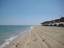
Khawr al Udayd's beach is a popular tourist attraction in Qatar.[13] The most common routes to the beach are via Mazrat Turaina and Mesaieed.[14]
Demographics
As of the 2010 census, the settlement comprised 14 housing units[15] and 4 establishments.[16] There were 42 people living in the settlement, of which 100% were male and 0% were female. Out of the 42 inhabitants, 100% were 20 years of age or older and 0% were under the age of 20. The literacy rate stood at 64.3%.[17]
Employed persons made up 100% of the total population. Males accounted for 100% of the working population.[17]
| Year | Population |
|---|---|
| 2010[18] | 42 |
| 2015[19] | 7 |
References
- ↑ "Khor Al Adaid Reserve". Qatar eNature. Retrieved 24 June 2018.
- 1 2 "Arabian Boundary Disputes - Cambridge Archive Editions". Archiveeditions.co.uk. Retrieved 2017-01-21.
- 1 2 3 Moorehead, John (1977). In Defiance of The Elements: A Personal View of Qatar. Quartet Books. p. 54. ISBN 9780704321496.
- ↑ "'Gazetteer of the Persian Gulf. Vol I. Historical. Part IA & IB. J G Lorimer. 1915' [797] (952/1782)". Qatar Digital Library. Retrieved 14 August 2015.
- ↑ "'Gazetteer of the Persian Gulf. Vol I. Historical. Part IA & IB. J G Lorimer. 1915' [798] (953/1782)". Qatar Digital Library. Retrieved 14 August 2015.
- ↑ "'Extracts from Gazetteer of the Persian Gulf, Oman and Central Arabia by J G Lorimer CIE, Indian Civil Service' [46v] (97/180)". Qatar Digital Library. Retrieved 4 February 2016.
- ↑ Moorehead, John (1977). In Defiance of The Elements: A Personal View of Qatar. Quartet Books. p. 56. ISBN 9780704321496.
- ↑ "Archived copy". Archived from the original on 2009-09-05. Retrieved 2009-07-06.
- ↑ "Archived copy". Archived from the original on 2009-09-05. Retrieved 2009-07-06.
- ↑ Anisha Bijukumar (15 April 2017). "Approx 23 per cent of Qatar area is nature reserve". The Peninsula. Retrieved 24 June 2018.
- ↑ "Khor Al Adaid Reserve". Qatar eNature. Retrieved 24 June 2018.
- ↑ "Khor Al-Adaid natural reserve". UNESCO. Retrieved 24 June 2018.
- ↑ "Tourism". Ministry of Foreign Affairs. Retrieved 14 August 2015.
- ↑ "Khor Al Udeid beach: Joy with caution". The Peninsula Qatar. 5 July 2010. Retrieved 14 August 2015.
- ↑ "Housing units, by type of unit and zone (April 2010)" (PDF). Qatar Statistics Authority. Archived from the original (PDF) on 8 July 2015. Retrieved 9 August 2015.
- ↑ "Establishments by status of establishment and zone (April 2010)" (PDF). Qatar Statistics Authority. Archived from the original (PDF) on 8 July 2015. Retrieved 9 August 2015.
- 1 2 "Geo Statistics Application". Ministry of Development Planning and Statistics. Archived from the original on 11 September 2012. Retrieved 9 August 2015.
- ↑ "2010 population census" (PDF). Qatar Statistics Authority. Archived from the original (PDF) on 2 April 2015. Retrieved 29 June 2015.
- ↑ "2015 Population census" (PDF). Ministry of Development Planning and Statistics. April 2015. Retrieved 8 August 2017.
External links
| Administrative zones | |
|---|---|
| Other areas |
|