Kafr Thulth
| Kafr Thulth | |
|---|---|
| Other transcription(s) | |
| • Arabic | كفر ثلث |
| • Also spelled | Kufr Thulth (official) |
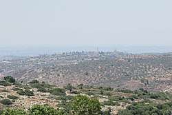 Kafr Thulth from the east | |
 Kafr Thulth Location of Kafr Thulth within Palestine | |
| Coordinates: 32°9′9″N 35°2′39″E / 32.15250°N 35.04417°ECoordinates: 32°9′9″N 35°2′39″E / 32.15250°N 35.04417°E | |
| Palestine grid | 154/173 |
| Governorate | Qalqilya |
| Government | |
| • Type | Municipality |
| • Head of Municipality | Hussein al-Saifi |
| Area | |
| • Jurisdiction | 24,938 dunams (24.9 km2 or 9.6 sq mi) |
| Elevation[1] | 173 m (568 ft) |
| Population (2007)[2] | |
| • Jurisdiction | 3,921 |
| Name meaning | "The ruin of the village of the third part"[3] |
Kafr Thulth (Arabic: كفر ثلث) is a Palestinian town located on high, flat land south of Azzoun, 28 kilometers (17 mi) south of Tulkarm in the Qalqilya Governorate. The average elevation is 270 meters (890 ft) above sea level. According to the Palestinian Central Bureau of Statistics, the town's population was 3,921[2] in the 2007 census.
Name
Kafr in Syriac means "village" and Thulth means "three" or "a third".[3] This Syriaic name preserves the place name of Baal-shalisha,[4] an ancient village believed to have been located 3.5 miles (5.6 km) to the south at a site known in modern times as Khirbat Sirisya.[5]
Geography
Kafr Thulth is bordered by Azzun to the south, Sanniriya and Biddya villages to the east and Deir Istiya to the west. In 1948, parts of Kharab and Aizab, such as, Salman, al-Moudwer, al-Sheikh Ahmad, al-Ashqar, Ras Tirah, al-Dabha, Kirash Kherba and Ras Atiya — villages or land areas that originally belonged to Kafr Thulth were separated from the town by the Green Line, which forms the border between Israel and the West Bank.
Kafr Thulth's land was extended to the border of the Auja stream and by the 19th century the town's total land area was about 50-60,000 dunams. It had bordered Habla, Jaljuliya, Azzun and Islah, but Kafr Thulth's jurisdiction decreased in 1954; Then, the distance was 924 dunams, while the distance reached up to Kherash Kherba that belong to Kafr Thulth 3,665 dunams.
History
Ottoman era
In 1517, the village was incorporated into the Ottoman Empire with the rest of Palestine, and in 1596, Kafr Tult appeared in Ottoman tax registers as being in nahiya (subdistrict) of Jabal Qubal under the liwa' (district) of Nablus. It had a population of 13 households and 1 batchelor, all Muslims. They paid a fixed tax rate of 33,3%, on wheat, barley, summer crops, occasional revenues, goats and/or beehives; a total of 1,100 akçe.[6]
In 1838, Kafr Thulth was included in a village list drawn up by Edward Robinson, part of Jurat Merda, south of Nablus, named as Kefr Telet.[7]
In 1852, Robinson described Kafr Thulth as "a ruin",[8] and the same did Victor Guérin in 1870.[9] However, later researchers have noted that both only saw Kafr Thulth from a distance, and might have had it mixed up with the ruin Kufr Qara.[10]
In 1882 the Palestine Exploration Fund's Survey of Western Palestine described the village (called Khurbet Kefr Thilth) as "a small village on high ground, with two wells. It was in ruins in 1852, but has now a few inhabitants, the ground round is rough and uncultivated."[4]
British Mandate era
In the 1922 census of Palestine conducted by the British Mandate authorities, Kufr Thelth had a population of 643, all Muslims,[11] while in the 1931 census Kafr Thulth, (including Khirbat Khris), had 169 occupied houses and a population of 955, still all Muslim.[12]
Land ownership in 1945
| Ethnic group | Land ownership (dunums)[13][14] |
|---|---|
| Arab | 24,851 |
| Jewish | 82 |
| Public | 5 |
| Total | 24,938 |
Land usage in 1945
| Land usage type[13][15] | Arab (dunum) | Jewish (dunum) |
|---|---|---|
| Irrigated and plantation | 1,629 | 0 |
| Area planted with olives | 1,921 | 0 |
| Planted with cereals | 6,329 | 62 |
| Built up[16] | 55 | 0 |
| Cultivable | 7,958 | 62 |
| Non-cultivable | 16,843 | 20 |
| Lands usurped within armistice area | 0 | 1,241 dunums |
Jordanian era
In the wake of the 1948 Arab–Israeli War, and after the 1949 Armistice Agreements, Kafr Thulth came under Jordanian rule.
In 1961, the population of Kafr Thulth was 1,213.[17]
1967-present
After the Six-Day War in 1967, Kafr Thulth has been under Israeli occupation.
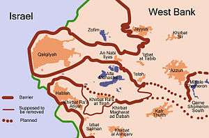
After the 1995 accords, about 10.7% of the land is classified as being Area B, while the remaining 89.3 % is Area C.[18] Israel has confiscated 367 dunums of village land for the construction of the Israeli settlements of Karne Shomron, Ginot Shomron, Ma’ale Shomron and Emmanuel, in addition to taking land for the construction of the Segregation Wall.[19]
References
- ↑ Kafr Thulth Town Profile (including ‘Arab al Khawla Locality), ARIJ, p. 4
- 1 2 Census 2007 Locality Population Statistics Archived 2010-12-10 at the Wayback Machine.. Palestinian Central Bureau of Statistics
- 1 2 Palmer, 1881, p. 234
- 1 2 Conder and Kitchener, 1882, SWP II, p. 285
- ↑ Freedman et al., 2000, p. 136.
- ↑ Hütteroth and Abdulfattah, 1977, p. 132
- ↑ Robinson and Smith, 1841, vol 3, 2nd appendix, p.126
- ↑ Robinson and Smith, 1856, p. 136
- ↑ Guérin, 1875, p. 176
- ↑ Grossman and Safrai, 1980, p. 453.
- ↑ Barron, 1923, Table IX, Sub-district of Nablus, p. 26
- ↑ Mills, 1931, p. 65
- 1 2 Government of Palestine, Department of Statistics, 1945, p. 21
- ↑ Government of Palestine, Department of Statistics. Village Statistics, April, 1945. Quoted in Hadawi, 1970, p. 75
- ↑ Government of Palestine, Department of Statistics. Village Statistics, April, 1945. Quoted in Hadawi, 1970, p. 126
- ↑ Government of Palestine, Department of Statistics. Village Statistics, April, 1945. Quoted in Hadawi, 1970, p. 176
- ↑ Government of Jordan, 1964, p. 27
- ↑ Kafr Thulth Town Profile (including ‘Arab al Khawla Locality), ARIJ, p. 16
- ↑ Kafr Thulth Town Profile (including ‘Arab al Khawla Locality), ARIJ, p. 17
Bibliography
- Barron, J. B., ed. (1923). Palestine: Report and General Abstracts of the Census of 1922. Government of Palestine.
- Conder, C.R.; Kitchener, H. H. (1882). The Survey of Western Palestine: Memoirs of the Topography, Orography, Hydrography, and Archaeology. 2. London: Committee of the Palestine Exploration Fund.
- Freedman, D.N.; Myers, Allen C.; Beck, Astrid B. (2000). Eerdmans dictionary of the Bible (Illustrated ed.). Wm. B. Eerdmans Publishing. ISBN 9780802824004.
- Government of Jordan, Department of Statistics (1964). First Census of Population and Housing. Volume I: Final Tables; General Characteristics of the Population (PDF).
- Government of Palestine, Department of Statistics (1945). Village Statistics, April, 1945.
- Grossman, David; Safrai, Z. (1980). "Satellite Settlements in Western Samaria". Geographical Review. American Geographical Society. 70 (4): 446–461. JSTOR 214078.
- Guérin, V. (1875). Description Géographique Historique et Archéologique de la Palestine (in French). 2: Samarie, pt. 2. Paris: L'Imprimerie Nationale.
- Hadawi, S. (1970). Village Statistics of 1945: A Classification of Land and Area ownership in Palestine. Palestine Liberation Organization Research Center.
- Hütteroth, Wolf-Dieter; Abdulfattah, Kamal (1977). Historical Geography of Palestine, Transjordan and Southern Syria in the Late 16th Century. Erlanger Geographische Arbeiten, Sonderband 5. Erlangen, Germany: Vorstand der Fränkischen Geographischen Gesellschaft. ISBN 3-920405-41-2.
- Mills, E., ed. (1932). Census of Palestine 1931. Population of Villages, Towns and Administrative Areas. Jerusalem: Government of Palestine.
- Palmer, E. H. (1881). The Survey of Western Palestine: Arabic and English Name Lists Collected During the Survey by Lieutenants Conder and Kitchener, R. E. Transliterated and Explained by E.H. Palmer. Committee of the Palestine Exploration Fund.
- Robinson, E.; Smith, E. (1841). Biblical Researches in Palestine, Mount Sinai and Arabia Petraea: A Journal of Travels in the year 1838. 3. Boston: Crocker & Brewster.
- Robinson, E.; Smith, E. (1856). Later Biblical Researches in Palestine and adjacent regions: A Journal of Travels in the year 1852. London: John Murray.
External links
- Palestine Remembered Kafr Thulth Page
- Survey of Western Palestine, Map 14: IAA, Wikimedia commons
- Kafr Thulth Town (including ‘Arab al Khawla Locality) (Fact Sheet), Applied Research Institute–Jerusalem, (ARIJ)
- Kafr Thulth Town Profile (including ‘Arab al Khawla Locality), ARIJ
- Kafr Thulth, aerial photo, ARIJ
- Development Priorities and Needs in Kufr Thulth (including ‘Arab al Khawla Locality), ARIJ
- Resumption of Wall constructions in Kafr Thulth and Azzun lands – Qalqiliya governorate August 29, 2005, POICA
| Cities |  | |
|---|---|---|
| Municipalities |
| |
| Villages |
| |