Immatain
| Immatain | |
|---|---|
| Other transcription(s) | |
| • Arabic | إماتين |
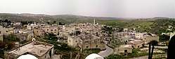 Viewpoint of Immatain | |
 Immatain Location of Immatain within Palestine | |
| Coordinates: 32°11′31″N 35°09′27″E / 32.19194°N 35.15750°ECoordinates: 32°11′31″N 35°09′27″E / 32.19194°N 35.15750°E | |
| Palestine grid | 165/177 |
| Governorate | Qalqilya |
| Founded | 1250 (estimate) |
| Government | |
| • Type | Village council |
| • Head of Municipality | Haythem Sameer Sawan |
| Area | |
| • Jurisdiction | 10,000 dunams (10.0 km2 or 3.9 sq mi) |
| Elevation[1] | 432-518 m (−1,267 ft) |
| Population (2006) | |
| • Jurisdiction | 2,450 |
| Name meaning | Amatin p.n.,[2] |
Immatain (Arabic: إماتين) is a Palestinian village located in the Qalqilya Governorate in the northwestern West Bank, about seventeen kilometers southwest of Nablus. The current mayor of Immatain is Haythem Sawan.
After 2012, the village of Farratin is included in Immatain.
Location
Immatin (including the Far’ata locality) is located 19 kilometers (12 mi) west of Qalqiliya. It is bordered by Tell to the east, Deir Istiya to the south, Jinsafut, Al Funduq and Hajja to the west, and Kafr Qaddum and Jit to the north.[1]
History
Byzantine ceramics have been found in the village.[3]
Ottoman era
Immatain was incorporated into the Ottoman Empire in 1517 with all of Palestine, and in 1596 Immatain appeared in the tax registers as Matin, being in the Nahiya of Jabal Qubal of the Liwa of Nablus. It had a population of 20 households and 1 bachelor, all Muslim. The villagers paid a fixed tax rate of 33,3% on a number of crops, including wheat, barley, summer crops, olives, goats and beehives; a total of 3,000 Akçe.[4]
In 1838, Amatin was noted as located in Jurat Amra, south of Nablus.[5]
In Palestine Exploration Fund's Survey of Western Palestine (1882), Immatain was described as "a village of moderates size on the slope of the hill, with a few olives."[6]
British Mandate era
In the 1922 census of Palestine conducted by the British Mandate authorities, Immatain (called "Ammatain") had a population of 234, all Muslim,[7] increasing in the 1931 census to 334 Muslims in 67 houses.[8]
In the 1945 statistics the population of Immatin was 440, all Muslims,[9] while the total land area was 7,155 dunams, according to an official land and population survey.[10] Of this, 967 were allocated for plantations and irrigable land, 3,067 for cereals,[11] while 32 dunams were classified as built-up areas.[12]
Land ownership of Immatain in 1945
The following is a breakdown of land ownership in 1945.[10][9]
| Ethnic group | Land ownership (dunams) | Land ownership (%) |
|---|---|---|
| Arab | 7,152 | 99.9% |
| Jewish | 0 | 0% |
| Christian | 0 | 0% |
| Public | 3 | 0.0004% |
Land usage of Immatain in 1945
The following is a breakdown of the land usage during 1945 in the dunams.[11][9]
| Land usage type | Arab dunams | Percentage |
|---|---|---|
| Irrigated and plantation | 967 | 8% |
| Area planted with olives | 1,042 | 9% |
| Area planted with cereal | 3,067 | 25% |
| Built-up | 32 | 0.3% |
| Cultivable | 4,034 | 33% |
| Non-cultivable | 3,089 | 24.7% |
| Total | 12,240 | 100% |
Jordanian era
In the wake of the 1948 Arab–Israeli War, and after the 1949 Armistice Agreements, Immatain came under Jordanian rule.
The Jordanian census of 1961 found 782 inhabitants in Immatin.[13]
Post-1967
After the Six-Day War in 1967, Immatain has been under Israeli occupation.
After the 1995 accords, 58.3% of the total village land of Immatain/Fara'ata is defined as Area B land, while the remaining 41,7% is defined as Area C land.[14] Israel has confiscated 163 dunams of land from Immatain for the construction of the Israeli settlement of ‘Sha’ar Emmanuel’, part of the Immanuel settlement.[15]
Population
According to the Palestinian Central Bureau of Statistics, Immatain had a population of approximately 2,450 inhabitants in mid-year 2006.[16] Almost double the amount live abroad for political and economical reasons. Each year, on average two family units emigrate from Immatain. Immatain has four families. They are Sawan, Ghanim, Albaree, and Matanee.
| Family name | Population est. | Percent of the population |
|---|---|---|
| Sawan | 1220 | 49.8% |
| Ghanim | 850 | 34.7% |
| Albaree | 255 | 10.4% |
| Matanee | 125 | 5.1% |
Population growth (1922 - 2007)[17]

Footnotes
- 1 2 Immatin Village Profile (including Far’ata Locality), ARIJ, p. 4
- ↑ Palmer, 1881, p. 178
- ↑ Dauphin, 1998, p. 800
- ↑ Hütteroth and Abdulfattah, 1977, p. 136
- ↑ Robinson and Smith, 1841, vol 3, Appendix 2, p. 127
- ↑ Conder and Kitchener, 1882, SWP II, p. 162
- ↑ Barron, 1923, Table IX, Sub-district of Nablus, p. 25
- ↑ Mills, 1932, p. 62
- 1 2 3 Government of Palestine, Department of Statistics, 1945, p. 18
- 1 2 Government of Palestine, Department of Statistics. Village Statistics, April, 1945. Quoted in Hadawi, 1970, p. 60
- 1 2 Government of Palestine, Department of Statistics. Village Statistics, April, 1945. Quoted in Hadawi, 1970, p. 106
- ↑ Government of Palestine, Department of Statistics. Village Statistics, April, 1945. Quoted in Hadawi, 1970, p. 156
- ↑ Government of Jordan, Department of Statistics, 1964, p. 25
- ↑ Immatin Village Profile (including Far’ata Locality), ARIJ, p. 16
- ↑ Immatin Village Profile (including Far’ata Locality), ARIJ, p. 17
- ↑ Projected Mid -Year Population for Qalqilya Governorate by Locality 2004- 2006 Palestinian Central Bureau of Statistics.
- ↑ "Immatin - اماتين -Nablus - Palestine Remembered". www.palestineremembered.com. Retrieved 2016-02-01.
Bibliography
- Barron, J. B., ed. (1923). Palestine: Report and General Abstracts of the Census of 1922. Government of Palestine.
- Conder, C.R.; Kitchener, H. H. (1882). The Survey of Western Palestine: Memoirs of the Topography, Orography, Hydrography, and Archaeology. 2. London: Committee of the Palestine Exploration Fund.
- Dauphin, Claudine (1998). La Palestine byzantine, Peuplement et Populations. BAR International Series 726 (in French). III : Catalogue. Oxford: Archeopress. ISBN 0-860549-05-4.
- Government of Jordan, Department of Statistics (1964). First Census of Population and Housing. Volume I: Final Tables; General Characteristics of the Population (PDF).
- Government of Palestine, Department of Statistics (1945). Village Statistics, April, 1945.
- Guérin, V. (1875). Description Géographique Historique et Archéologique de la Palestine (in French). 2: Samarie, pt. 2. Paris: L'Imprimerie Nationale.
- Hadawi, S. (1970). Village Statistics of 1945: A Classification of Land and Area ownership in Palestine. Palestine Liberation Organization Research Center.
- Hütteroth, Wolf-Dieter; Abdulfattah, Kamal (1977). Historical Geography of Palestine, Transjordan and Southern Syria in the Late 16th Century. Erlanger Geographische Arbeiten, Sonderband 5. Erlangen, Germany: Vorstand der Fränkischen Geographischen Gesellschaft. ISBN 3-920405-41-2.
- Mills, E., ed. (1932). Census of Palestine 1931. Population of Villages, Towns and Administrative Areas. Jerusalem: Government of Palestine.
- Palmer, E. H. (1881). The Survey of Western Palestine: Arabic and English Name Lists Collected During the Survey by Lieutenants Conder and Kitchener, R. E. Transliterated and Explained by E.H. Palmer. Committee of the Palestine Exploration Fund.
- Robinson, E.; Smith, E. (1841). Biblical Researches in Palestine, Mount Sinai and Arabia Petraea: A Journal of Travels in the year 1838. 3. Boston: Crocker & Brewster.
External links
- Welcome To Immatin
- Survey of Western Palestine, Map 11: IAA, Wikimedia commons
- Immatin Village (including Far’ata Locality) (Fact Sheet), Applied Research Institute–Jerusalem (ARIJ)
- Immatin Village Profile (including Far’ata Locality), ARIJ
- Immatin, aerial photo, ARIJ
- Development Priorities and Needs in Imatin (including Far’ata Locality), ARIJ
- Israeli Hoax of Barriers removal 22, June,2004
- New Palestinian Enclaves created by the Israeli updated wall map around Ariel Settlement Bloc. 14, June, 2006, POICA
- Testimony: Settlers attack Palestinian farmers on their land, Jan. '09, B'Tselem
- Gilad Zoher colony: a source of continuous aggression against Palestinian farmers, 20, May, 2009, POICA
- Harvest under Fire, This week in Palestine
| Cities |  | |
|---|---|---|
| Municipalities |
| |
| Villages |
| |