Kensaleyre
Kensaleyre
| |
|---|---|
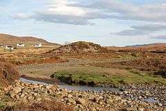 Carn Liath in Kensaleyre. This Carn Liath is one of many features of that name throughout the Scottish highlands. It is a four metre high chambered cairn | |
 Kensaleyre Kensaleyre shown within the Isle of Skye | |
| OS grid reference | NG422514 |
| Council area | |
| Country | Scotland |
| Sovereign state | United Kingdom |
| Post town | Snizort |
| Postcode district | IV51 9 |
| Police | Scottish |
| Fire | Scottish |
| Ambulance | Scottish |
| EU Parliament | Scotland |
| UK Parliament | |
| Scottish Parliament | |
Kensaleyre (Scottish Gaelic: Ceann Sàil Eighre) is scattered crofting township, part of a group of settlements clustered around the A87 road on the shore of Loch Snizort Beag[1][2] on the Trotternish peninsula of the island of Skye in the Highlands and Islands of Scotland. It is in the council area of Highland.
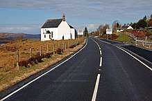
Snizort Parish Church, Kensalyre
References
- ↑ Microsoft; Nokia (7 March 2017). "Kensaleyre" (Map). Bing Maps. Microsoft. Retrieved 7 March 2017.
- ↑ Gittings, Bruce; Munro, David. "Kensaleyre". The Gazetteer for Scotland. School of GeoSciences, University of Edinburgh and The Royal Scottish Geographical Society. Retrieved 17 August 2018.
| Wikimedia Commons has media related to Kensaleyre. |
This article is issued from
Wikipedia.
The text is licensed under Creative Commons - Attribution - Sharealike.
Additional terms may apply for the media files.