Sgùrr nan Gillean
| Sgùrr nan Gillean | |
|---|---|
 Sgurr nan Gillean, Am Basteir and Sgurr a'Bhasteir from the Sligachan hotel | |
| Highest point | |
| Elevation | 964 m (3,163 ft) [1] |
| Prominence | c. 204 m |
| Parent peak | Sgùrr Alasdair |
| Listing | Munro, Marilyn |
| Naming | |
| Translation | Peak of the young men (Gaelic) |
| Pronunciation | Scottish Gaelic: [ˈs̪kuːrˠ nəŋ ˈkʲiʎən] |
| Geography | |
| Location | Skye, Scotland |
| Parent range | Cuillin |
| OS grid | NG471252 |
| Topo map | OS Landranger 32 |
| Climbing | |
| First ascent | 7 July 1836, by Duncan Macintyre and James Forbes |
| Easiest route | Scramble |
| Listed summits of Sgùrr nan Gillean | ||||
| Name | Grid ref | Height | Status | |
|---|---|---|---|---|
| Knight's Peak | NG471254 | 914 m | Corbett Top | |
| Sgùrr Beag | NG476246 | 764 m | Corbett Top | |
| Sgùrr na h-Uamha | NG476240 | 736 m | Graham Top | |
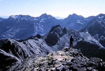
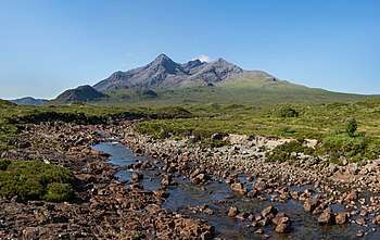
Sgùrr nan Gillean is a mountain in the northern section of the Cuillin range on the Isle of Skye in Scotland. With a height of 964 m (3162 feet) it is one of eleven Munros on the Cuillin ridge. It is the Munro closest to Sligachan, and its impressive triangular profile is visible behind the Sligachan hotel, making it perhaps the most recognised peak in the Cuillin range.
Routes
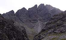
The most popular route of ascent, known as the Tourist Route, follows a path leading south and west from Sligachan, crossing a burn known as the Allt Dearg Beag (small red burn). The route continues up into a corrie, the Coire Rhiabhach. The ascent of the coire headwall is on loose rock and scree. The continuation up the southeast ridge to the summit is exposed, and calls for scrambling ability. The path up is very narrow so calls for single file when a party ascends. The top is a ridge which must be traversed to reach the final summit, and like the climb, needs some scrambling ability. All sides are very exposed, and extra care is needed if mist descends. The small airy summit platform is surprisingly smooth and flat with outstanding views.
An alternative route is the north ridge, known as Pinnacle Ridge, which is a rock climb that requires a climber to have a rope and harness and be capable of abseiling, unless the third pinnacle is omitted by bypassing on the east side. While rope is a sensible option for the moderate climb up Gillean, it is not required for Knight's Peak if the correct route is taken. To reach the base of the Pinnacle Ridge a climber starts in the same place as for the route described above but instead of crossing the burn continues up hill on the right hand side until just below the start of the Basteir gorge when the stream exiting the gorge is crossed to reach the base of the lowest pinnacle.
Another alternative route of ascent or descent is the West Ridge. It leads from the summit down to a bealach separating Sgùrr nan Gillean from Am Basteir. About two-thirds of the way down, there is a particularly narrow and exposed section, which forms the remains of a large upright rock, known as the Gendarme which broke away due to the effects of frost shatter during the winter of 1986/87, leaving only the base. The narrow section can be avoided by abseiling down (or climbing up) a gully, known as Nicholson's Chimney, on the north side of the ridge.
Name and classification
In November 2013 it was found that Knight's Peak is six and a half inches too short to be classified as a Munro Top (a satellite peak of a Munro being over 3,000 feet (914 m) but without significant height drop between the two peaks) and is now considered a Corbett Top.[2] Knight's Peak was named after W. Knight, who, with a guide, made the first recorded ascent in 1873.[3]
References
- ↑ "Walkhighlands Sgurr nan Gillean". walkhighlands.co.uk. walkhighlands.co.uk. 2013. Retrieved 13 October 2013.
- ↑ BBC News Scotland
- ↑ Grough News