Keningau Airport
| Keningau Airport 根地咬机场 | |||||||||||
|---|---|---|---|---|---|---|---|---|---|---|---|
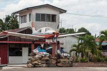
 The main entrance to Keningau Airport | |||||||||||
| Summary | |||||||||||
| Airport type | Private and public | ||||||||||
| Owner | Government of Malaysia | ||||||||||
| Operator | Malaysia Airports Holdings Berhad | ||||||||||
| Serves | Keningau, Sabah, Malaysia | ||||||||||
| Location | Interior Division, Sabah, East Malaysia | ||||||||||
| Time zone | MST (UTC+08:00) | ||||||||||
| Elevation AMSL | 1,036 ft / 316 m | ||||||||||
| Coordinates | 05°21′19″N 116°09′54″E / 5.35528°N 116.16500°ECoordinates: 05°21′19″N 116°09′54″E / 5.35528°N 116.16500°E | ||||||||||
| Map | |||||||||||
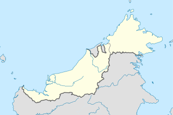 WBKG Location in Malaysia | |||||||||||
| Runways | |||||||||||
| |||||||||||
Keningau Airport (Malay: Lapangan Terbang Keningau) (IATA: KGU, ICAO: WBKG) is a privately owned domestic airport serving the city of Keningau in the state of Sabah, Malaysia. It is 2.5 km from Keningau Town.
History
Keningau Airport's old control tower
Many years ago, the Keningau Airport was used for aeroplanes with a small capacity like the BN-2 Islander and Fokker F27. The last flight to Keningau Airport for Malaysia Airlines was in the 1970s.
Airlines and destinations
Malaysia Airlines used to fly from Subang Airport (now Kuala Lumpur International Airport) to Keningau Airport. When Malaysia Airlines stopped this flight, they ended the Kuala Lumpur-Keningau route and turned it an abandoned airport. There are no scheduled commercial airlines flying to Keningau.
See also
References
- ↑ AIP Malaysia: Index to Aerodromes at Department of Civil Aviation Malaysia
This article is issued from
Wikipedia.
The text is licensed under Creative Commons - Attribution - Sharealike.
Additional terms may apply for the media files.