Kemblawarra, New South Wales
| Kemblawarra Wollongong, New South Wales | |||||||||||||||
|---|---|---|---|---|---|---|---|---|---|---|---|---|---|---|---|
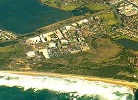 Aerial view from east | |||||||||||||||
|
Kemblawarra | |||||||||||||||
| Coordinates | 34°29.5′S 150°53.5′E / 34.4917°S 150.8917°ECoordinates: 34°29.5′S 150°53.5′E / 34.4917°S 150.8917°E | ||||||||||||||
| Postcode(s) | 2505[1] | ||||||||||||||
| LGA(s) | City of Wollongong | ||||||||||||||
| State electorate(s) | Wollongong | ||||||||||||||
| Federal Division(s) | Cunningham | ||||||||||||||
| |||||||||||||||
Kemblawarra is a residential, commercial and light industrial area of Wollongong, New South Wales, Australia. It is officially designated an urban place,[2] and comprises the southern part of Port Kembla.
References
- ↑ White Pages Canberra 2008
- ↑ "Kemblawarra". Geographical Names Register (GNR) of NSW. Geographical Names Board of New South Wales. Retrieved 4 August 2013.
This article is issued from
Wikipedia.
The text is licensed under Creative Commons - Attribution - Sharealike.
Additional terms may apply for the media files.