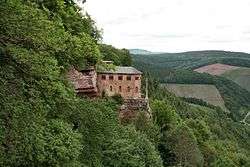
Kastel-Staadt
| Kastel-Staadt | ||
|---|---|---|
 | ||
| ||
 Kastel-Staadt Location of Kastel-Staadt within Trier-Saarburg district 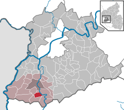 | ||
| Coordinates: 49°33′53″N 6°33′35″E / 49.56472°N 6.55972°ECoordinates: 49°33′53″N 6°33′35″E / 49.56472°N 6.55972°E | ||
| Country | Germany | |
| State | Rhineland-Palatinate | |
| District | Trier-Saarburg | |
| Municipal assoc. | Saarburg | |
| Government | ||
| • Mayor | Harald Lehnertz | |
| Area | ||
| • Total | 5.23 km2 (2.02 sq mi) | |
| Elevation | 330 m (1,080 ft) | |
| Population (2017-12-31)[1] | ||
| • Total | 419 | |
| • Density | 80/km2 (210/sq mi) | |
| Time zone | CET/CEST (UTC+1/+2) | |
| Postal codes | 54441 | |
| Dialling codes | 06582 | |
| Vehicle registration | TR | |
| Website | www.kastel-staadt.de | |

Kastel-Staadt is a municipality in the Trier-Saarburg district, in Rhineland-Palatinate, Germany.
History
From 18 July 1946 to 6 June 1947 Kastel-Staad, in its then municipal boundary, formed part of the Saar Protectorate.
References
- ↑ Statistisches Landesamt Rheinland-Pfalz "Bevölkerungsstand 2017 - Gemeindeebene" Check
|url=value (help). Statistisches Landesamt Rheinland-Pfalz (in German). 2018.
This article is issued from
Wikipedia.
The text is licensed under Creative Commons - Attribution - Sharealike.
Additional terms may apply for the media files.