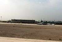
Kashgar Airport
| Kashgar Airport 喀什机场 Kāshí Jīchǎng قەشقەر ئايىرپورت | |||||||||||
|---|---|---|---|---|---|---|---|---|---|---|---|
 | |||||||||||
| Summary | |||||||||||
| Airport type | Public | ||||||||||
| Operator | Government | ||||||||||
| Serves | Kashgar | ||||||||||
| Elevation AMSL | 4,529 ft / 1,380 m | ||||||||||
| Coordinates | 39°32′35″N 076°01′12″E / 39.54306°N 76.02000°E | ||||||||||
| Maps | |||||||||||
 CAAC airport chart | |||||||||||
 KHG Location of airport in Xinjiang | |||||||||||
| Runways | |||||||||||
| |||||||||||
| Statistics (2015) | |||||||||||
| |||||||||||
Kashgar Airport (simplified Chinese: 喀什机场; traditional Chinese: 喀什機場; pinyin: Kāshí Jīchǎng; Uyghur: قەشقەر ئايىرپورت, Қәшқәр Айропорт ) (IATA: KHG, ICAO: ZWSH), also known as Kashi Airport, is an airport serving Kashgar (also known as Kashi),[1] a city in Uyghur autonomous region of Xinjiang in the People's Republic of China.[2]
Facilities
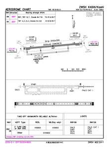
The airport resides at an elevation of 4,529 feet (1,380 m) above mean sea level. It has one runway designated 08/26 with a concrete surface measuring 3,200 by 41 metres (10,499 ft × 135 ft).[1]
Airlines and destinations
See also
Footnotes
- 1 2 3 Airport information for Kashi (ZWSH) from DAFIF (effective October 2006)
- 1 2 Airport information for Kashgar, Xinjiang, China (KHG / ZWSH) at Great Circle Mapper.
- ↑ http://www.caac.gov.cn/XXGK/XXGK/TJSJ/201603/P020160331391016414029.xls
- ↑ "PEGASUS LAUNCHES FLIGHTS TO XINJIANG'S KASHGAR VIA BISHKEK". Incentive Travel & Corporate Meetings. 21 September 2016. Retrieved 21 September 2016.
External links
- Current weather for Kashi, China (ZWSH) at NOAA/NWS
- Accident history for KHG / ZWSH at Aviation Safety Network
This article is issued from
Wikipedia.
The text is licensed under Creative Commons - Attribution - Sharealike.
Additional terms may apply for the media files.