Karaberd, Shirak
Coordinates: 40°32′37″N 43°49′40″E / 40.54361°N 43.82778°E
| Karaberd Քարաբերդ | |
|---|---|
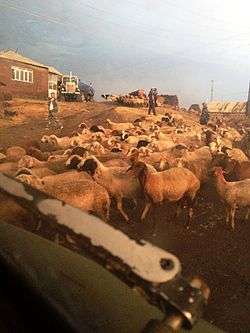 Bringing sheep back to the village | |
 Karaberd | |
| Coordinates: 40°32′37″N 43°49′40″E / 40.54361°N 43.82778°E | |
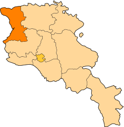
| Country | Armenia |
| Marz (Province) | Shirak |
| Population (2001) | |
| • Total | 1,090 |
| Time zone | UTC+4 ( ) |
| • Summer (DST) | UTC+5 ( ) |
Karaberd (Armenian: Քարաբերդ, also Romanized as K’araberd; formerly, Dashkala) is a village in the Shirak Province of Armenia.
Population
Population per years is the following.[1]
| Year | 1831 | 1887 | 1926 | 1939 | 1959 | 1970 | 2001 | 2004 |
|---|---|---|---|---|---|---|---|---|
| Pop. | 87 | 606 | 769 | 743 | 475 | 115 | 107 | 94 |
References
- ↑ "Dictionary of Armenian residences (Հայաստանի հանրապետության բնակավայրերի բառարան), page 206" (PDF). Retrieved April 18, 2014.
- Karaberd, Shirak at GEOnet Names Server
- Report of the results of the 2001 Armenian Census, National Statistical Service of the Republic of Armenia
This article is issued from
Wikipedia.
The text is licensed under Creative Commons - Attribution - Sharealike.
Additional terms may apply for the media files.