Getap, Shirak
| Getap Գետափ | |
|---|---|
| community | |
 Getap | |
| Coordinates: 40°39′N 44°00′E / 40.650°N 44.000°ECoordinates: 40°39′N 44°00′E / 40.650°N 44.000°E | |
| Country |
|
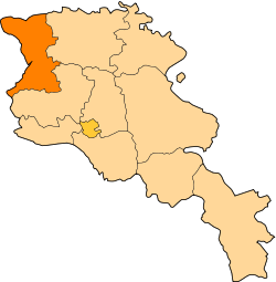
| Marz (Province) | Shirak |
| Population (2010) | |
| • Total | 822 |
| Time zone | UTC+4 ( ) |
| • Summer (DST) | UTC+5 ( ) |
| Getapi at GEOnet Names Server | |
Getap (Armenian: Գետափ; also Getapi; until 1940, Kasmali and Ghasm-Ali[1]) is a village and rural community (municipality) in the Shirak Province of Armenia. The National Statistical Service of the Republic of Armenia (ARMSTAT) reported its population was 822 in 2010,[2] up from 819 at the 2001 census.[3]
Population
Population per years is the following.[4]
| Տարի | 1831 | 1897 | 1926 | 1939 | 1959 | 1970 | 1979 | 2001 | 2004 |
|---|---|---|---|---|---|---|---|---|---|
| Բնակիչ | 84 | 503 | 640 | 674 | 654 | 661 | 606 | 819 | 822 |
References
- ↑ Kiesling, Rediscovering Armenia, p. 78, available online at the US embassy to Armenia's website Archived June 26, 2008, at the Wayback Machine.
- ↑ "Marzes of the Republic of Armenia and Yerevan City in Figures, 2010" (PDF). National Statistical Service of the Republic of Armenia (ARMSTAT).
- ↑ Report of the results of the 2001 Armenian Census, National Statistical Service of the Republic of Armenia
- ↑ "Dictionary of Armenian residences (Հայաստանի հանրապետության բնակավայրերի բառարան), page 58" (PDF). Retrieved April 18, 2014.
This article is issued from
Wikipedia.
The text is licensed under Creative Commons - Attribution - Sharealike.
Additional terms may apply for the media files.