Kaluđerica
| Kaluđerica Калуђерица | |
|---|---|
| Urban neighbourhood | |
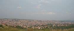 Panorama of Kaluđerica | |
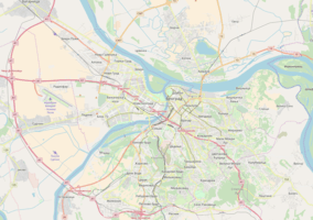 Kaluđerica Location within Belgrade | |
| Coordinates: 44°45′N 20°33′E / 44.750°N 20.550°ECoordinates: 44°45′N 20°33′E / 44.750°N 20.550°E | |
| Country |
|
| Region | Belgrade |
| Municipality | Grocka |
| Area | |
| • Total | 9.32 km2 (3.60 sq mi) |
| Population (2011) | |
| • Total | 26,904 |
| • Density | 2,900/km2 (7,500/sq mi) |
| Time zone | UTC+1 (CET) |
| • Summer (DST) | UTC+2 (CEST) |
| Area code | +381(0)11 |
| Car plates | BG |
Kaluđerica (Serbian Cyrillic: Калуђерица, pronounced [kalud͜ʑěrit͜sa]) is an urban neighborhood of Belgrade, the capital of Serbia. It is located in the municipality of Grocka.
Location
Kaluđerica is the westernmost settlement in the municipality of Grocka. It is located 6 kilometers east of central Belgrade and stretches in two fork-like urban formations between the road of Smederevski put to the north and the Belgrade-Niš highway to the south. The settlement is built in the hollow (micro valley of the Kaluđerički potok creek), with a specific microclimate, so out of all parts of Belgrade Kaluđerica is often the foggiest and the first one to have snow in winter.
History
Kaluđerica originated during the Ottoman rule of Serbia. A group of refugees who fled the Turks, settled at the bottom of the valley between two major roads. They cleared the thick woods around the creek and up to the 1950s, the settlement was predominantly agrarian, with most of the inhabitants working in agriculture and cattle breeding.[1]
Name
Nearby Bubanj Potok was the location of a monastery which owned land in the present Kaluđerica, so the name was derived from the word kaluđer which means a monk (kaluđerica - a monk's place), though in modern Serbian, word kaluđerica means a nun. Monastery was demolished in fire after the World War II.[1]
Characteristics
As the significant part of the settlement is built without permits and plans, none of the communal problems are even remotely solved. Kaluđerica is notorious for its lack of sewage, which during strong rains spills over in the streets, and smells during the summer.[1]
Situation is not better with the waterworks and electricity (which are, by the largest number, illegally conducted from the public lines) or transportation (short and bending streets, with only one straight street in the settlement, and only one daily bus line of the public transportation, 309). Kaluđerica probably has some of the worst conditions of any other neighborhoods in the City of Belgrade territory, excluding the informal settlements. With a total lack of control in the settlements expansion, in few cases it even happened that people would build houses in the middle of the street, disconnecting it.
Kaluđerica, in urban sense, grew with Belgrade’s most eastern part Mali Mokri Lug on the north, along the Smederevski put, and Veliki Mokri Lug to the south, divided from Kaluđerica (that is, from Kaluđerica's section of Klenak) by the highway.
Architects and urbanists describe Kaluđerica as an “undefined conglomerate of residential objects built against the law” or as an “example of deurbanisation which went beyond hope”.[1]
Population
| Historical population | ||
|---|---|---|
| Year | Pop. | ±% |
| 1910 | 696 | — |
| 1921 | 597 | −14.2% |
| 1931 | 795 | +33.2% |
| 1948 | 934 | +17.5% |
| 1953 | 1,011 | +8.2% |
| 1961 | 1,066 | +5.4% |
| 1971 | 1,909 | +79.1% |
| 1981 | 12,435 | +551.4% |
| 1991 | 17,580 | +41.4% |
| 2002 | 22,248 | +26.6% |
| 2011 | 26,904 | +20.9% |
| Source: [2][3][4][5] | ||
For several decades Kaluđerica was among the fastest growing settlements in Serbia. According to the latest census of the population, Kaluđerica had a population of 26,904 in 2011. It is three times more populous than its municipal seat, Grocka (population of 8,441 in 2011). However, most of the houses are built without the necessary building permits, so population is presumably much higher, especially after the wars in former Yugoslavia and the influx of the refugees from Bosnia and Hercegovina, Croatia and Kosovo and Metohija (journalists often nickname Kaluđerica the largest illegal settlement in Europe). Belgrade's City Public Transportation Company (GSP), Telekom Srbija and police, based on the number of people using their services, estimate the population between 45,000 and 50,000.[1]
Neighborhoods
As Kaluđerica rapidly developed, several distinct sub-neighborhoods within the settlement were formed. Those to the north, along the Smederevski put, are mostly named after the kafanas which had been the only features on the road before the settlement expanded.
- Čardak; easternmost extension of Kaluđerica, which extends from the neighborhood Tri Tiganja to the west and continues into the settlement of Leštane to the east and Radmilovac, across the road. Along and above the Smederevski put, it was named after kafana of the same name (Turkish: çardak, meaning "summerhouse").
- Donja Kaluđerica; largest part of Kaluđerica. It has two elementary schools, IDEA and Maxi shops, modern community health center, kindergarten and police station.
- Klenak; western extension. It is the highest part of the settlement, on the hill above, with a beautiful view on the rest of Kaluđerica. Klenak extends from Stara Kaluđerica, settlements old core to the east and stretches along the highway, with its western part in Zvezdara municipality, as the extension of Mali Mokri Lug. A bridge over the highway connects Klenak and Mali Mokri Lug with Veliki Mokri Lug, which expanded on the other side of the highway.
- Moravac; north-west extension, the closest part to Belgrade. Northern sections of the neighborhood, along the Smederevski put, are administratively part of the municipality of Zvezdara. It extends into the neighborhood of Mali Mokri Lug to the west, Novo Naselje to the east and Stara Kaluđerica to the south. Named after kafana of the same name (meaning "man from Morava").
- Novo Naselje; as the name suggests ("new settlement") is a new, rapidly developing and mostly commercial zone along the Smederevski put. It is located between the neighborhoods of Moravac (to the west), Tri Tiganja (to the east) and Stara Kaluđerica (to the south).
- Stara Kaluđerica (old Kaluđerica), the oldest core of the settlement, further to the south from the main road. Mostly located along the Vojvode Stepe Stepanovića street.
- Tri Tiganja; north-central section. It is an area where road which leads to the Belgrade city dump and the Nuclear Institute "Vinča" separates from the Smederevski put. There is a developing commercial zone along the road and the crossroads. It was named after kafana of the same name (meaning "three frying pans").
Notable people
Folk singers Mira Škorić and Sandra Afrika grew up in Kaluđerica.
References
- 1 2 3 4 5 Milan Četnik, "Krčevina između carskih drumova", Politika (in Serbian)
- ↑ Претходни резултати пописа становништва и домаће стоке у Краљевини Србији 31 декембра 1910 године, Књига V, стр. 12 [Preliminary results of the census of population and husbandry in Kingdom of Serbia on 31 December 1910, Vol. V, page 12]. Управа државне статистике, Београд (Administration of the state statistics, Belgrade). 1911.
- ↑ Final results of the census of population from 31 January 1921, page 354. Kingdom of Yugoslavia - General State Statistics, Sarajevo. June 1932.
- ↑ Final results of the census of population from 31 March 1931, page 60. Kingdom of Yugoslavia - General State Statistics, Belgrade. 1937.
- ↑ Comparative overview of the number of population in 1948, 1953, 1961, 1971, 1981, 1991, 2002 and 2011 – Data by settlements, page 29. Statistical Office of the Republic of Serbia, Belgrade. 2014. ISBN 978-86-6161-109-4.
Sources
- Jovan Đ. Marković (1990): Enciklopedijski geografski leksikon Jugoslavije; Svjetlost-Sarajevo; ISBN 86-01-02651-6
| Wikimedia Commons has media related to Kaluđerica. |
'FK Kaluđerica July 26 at 1:38 PM · Club history: Football Club Partizan Kalujerica was founded on October 20, 1969. year. in Belgrade, on the territory of Grocka municipality in the town of Kaludjerica. The seat of the club at that time was Ignjat Gige 1, on the site of the present church. The club was given a building permit to build premises, a restaurant and a field with stands, which the club itself built and for thirty years it was competing without any problems, in 1999, the then authorities, with the forgeries of the club members' signatures, and without their permission, gave the land patriarchy to build a church. In return, the club needed to get a new court with all the built rooms, restaurants and stands with its headquarters in Kaludjerica, street Zikica Jovanovica Spanca br 65 H, but not. The intention of the authorities was to shut down the club. The club continues to compete in the games as hosts on the courts of other clubs, but not to be extinguished. After a couple of years, we started on the new site, which was assigned to us, to make a football field from a landfill. We made a terrain with complete drainage, according to international standards, dimensions 105m × 68m. We built an administrative building with basements and finally, after a few years, we started playing on our terrain, but without electricity and regulated infrastructure, and in a constant fight with the municipality, because they will not help us in any way, and continue trying to get us out. Again, we were forced to play our matches in the field, until the last year, where we again made ourselves again and obtained a certificate from FS-Belgrade, that we can play games on our field. The club suffered various situations, and during that time it competed and was always in the upper part of the table. Thus, in the 2010-2011 season, the club played Grocka Municipal League and finished in 4th place, then season The 2011-2012 club competed in the Third Belgrade BIP League Group "A" and was 9th at the end of the season, The 2012-2013 club was in the Group A Third League and ended the competition as the 8th season. The 2013-2014 club is playing Inter-municipal League Belgrade - Group C and finishes as 6. In the season 2014-2015, the club is in the Inter-Municipal League Belgrade - group "C" and also finishes in 6th place. Season 2015-2016 starts in Grocka Municipal League and ends on 3rd place. Season 2017-2018. the club competes in the Inter-Municipal League Belgrade - Group "B" and finishes in the 9th place in the table. Klub od 07.25.2018. he changed his name to FK Kaluđerica and continued with that name a further stream of the competition. '