Kōzuke Province
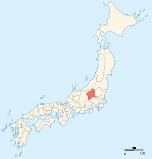
Kōzuke Province (上野国 Kōzuke-no kuni) was a province of Japan in the area of Japan that is today Gunma Prefecture.[1] Kōzuke bordered by Echigo, Shinano, Musashi and Shimotsuke Provinces. Its abbreviated form name was Jōshū (上州). Under the Engishiki classification system, Kōzuke was ranked as one of the 13 "great countries" (大国) in terms of importance, and one of the 30 "far countries" (遠国) in terms of distance from the capital. The provincial capital is located in what is now the city of Maebashi; however, its exact location remains uncertain. The ichinomiya of the province is located in what is now the city of Tomioka.
History
During the 4th century AD, (Kofun period) the area of modern Gunma and southern Tochigi prefectures were known as Keno or Kenu (毛野). At some unknown point in the 5th century, the area was divided at the Kinugawa River into Kamitsukeno (上毛野)(near-"keno") and Shimotsukeno (下毛野)(far-"keno"). Per the Nara period Taihō Code, these provinces became Kamitsukeno-no-kuni (上毛野国) and Shimotsukeno-no-kuni (下毛野国). In 713, with the standardization of province names into two kanji, these names became Kōzuke (上野) and Shimotsuke (下野).
From the Heian period, from the year 811, Kōzuke (along with Hitachi and Kazusa) was one of the three provinces where an Imperial Prince was designated as nominal ruler. The area was noted for its production of horses. The original capital of the province was located in what is now Maebashi, along with the kokubun-ji and the sōja of the province. The ichinomiya was located in what is now the city of Tomioka.
During the Sengoku period, Kōzuke was contested between the later Hōjō clan, the Takeda and the Uesugi clans. After the establishment of the Tokugawa Shogunate, much of the province was assigned to several feudal domains. The Nakasendō and the Mikuni Kaidō highways passed through the province, and numerous post stations were established.
Following the Meiji restoration, the various domains became prefectures with the abolition of the han system in 1871. These various prefectures merged to form Gunma Prefecture in 1876. The area subsequently prospered with the development of sericulture and silk spinning industries.
Historical districts
- Gunma Prefecture
- Agatsuma District (吾妻郡)
- Gunma District (群馬郡)
- Higashigunma District (東群馬郡) - merged with Minamiseta District to become the 2nd incarnation of Seta District (勢多郡) on April 1, 1896
- Nishigunma District (西群馬郡) - merged with Kataoka District to become the 2nd incarnation of Gunma District (群馬郡) on April 1, 1896
- Kanra District (甘楽郡)
- Kitakanra District (北甘楽郡) - renamed as Kanra District (甘楽郡) on April 1, 1950
- Minamikanra District (南甘楽郡) - merged with Midono and Tago Districts to become Tano District (多野郡) on April 1, 1896
- Kataoka District (片岡郡) - merged with Nishigunma District to become the 2nd incarnation of Gunma District on April 1, 1896
- Kitagunma District (北群馬郡) - split off from Gunma District on October 1, 1949
- Midono District (緑野郡) - merged with Minamikanra and Tago Districts to become Tano District on April 1, 1896
- Nawa District (佐波郡) - merged with Sai District to become Sawa District (佐波郡) on April 1, 1896
- Nitta District (新田郡) - dissolved
- Ōra District (邑楽郡)
- Sai District (佐波郡) - merged with Nawa District to become Sawa District on April 1, 1896
- Seta District (勢多郡)
- Kitaseta District (北勢多郡) - merged into Tone District on April 1, 1896
- Minamiseta District (南勢多郡) - merged with Higashigunma District to become the 2nd incarnation of Seta District on April 1, 1896
- Tago District (多胡郡) - merged with Minamikanra and Midono Districts to become Tano District on April 1, 1896
- Tone District (利根郡) - absorbed Kitaseta District on April 1, 1896
- Usui District (碓氷郡) - dissolved
- Yamada District (山田郡) – dissolved
Bakumatsu period domains
| Name | type | daimyo | kokudaka | notes |
|---|---|---|---|---|
| Maebashi Domain | fudai | Matsudaira | 170,000 koku | |
| Takasaki Domain | fudai | Ōkochi-Matsudaira | 82,000 koku | |
| Tatebayashi Domain | fudai | Akimoto | 63,000 koku | |
| Numata Domain | fudai | Toki | 35,000 koku | |
| Annaka Domain | fudai | Itakura | 30,000 koku | |
| Obata Domain | fudai | Okudaira-Matsudaira | 20,000 koku | |
| Isesaki Domain | fudai | Sakai | 20,000 koku | |
| Yoshii Domain | shimpan | Takatsukasa | 12,000 koku | |
| Nanukaichi Domain | tozama | Maeda | 10,000 koku | |
Notes
- ↑ Nussbaum, Louis-Frédéric. (2005). "Kōzuke" in Japan Encyclopedia, p. 990, p. 990, at Google Books.
References
- Nussbaum, Louis-Frédéric and Käthe Roth. (2005). Japan encyclopedia. Cambridge: Harvard University Press. ISBN 978-0-674-01753-5; OCLC 58053128
- Papinot, Edmond. (1910). Historical and Geographic Dictionary of Japan. Tokyo: Librarie Sansaisha. OCLC 77691250
- (in Japanese) Kōzuke on "Edo 300 HTML"
External links
![]()