Kōra, Shiga
| Kōra 甲良町 | ||
|---|---|---|
| Town | ||
 Saimyō-ji | ||
| ||
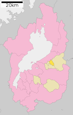 Location of Kōra in Shiga Prefecture | ||
 Kōra Location in Japan | ||
| Coordinates: 35°12′N 136°16′E / 35.200°N 136.267°ECoordinates: 35°12′N 136°16′E / 35.200°N 136.267°E | ||
| Country | Japan | |
| Region | Kansai | |
| Prefecture | Shiga Prefecture | |
| District | Inukami | |
| Government | ||
| • Mayor | Toyoaki Kitagawa | |
| Area | ||
| • Total | 13.66 km2 (5.27 sq mi) | |
| Population (October 1, 2016) | ||
| • Total | 6,932 | |
| • Density | 510/km2 (1,300/sq mi) | |
| Symbols | ||
| • Tree | Zelkova serrata | |
| • Flower | Wisteria | |
| Time zone | UTC+9 (JST) | |
| City hall address |
353-1, Zaiji, Kōra-chō, Inukami-gun, Shiga-ken 522-0244 | |
| Website |
www | |

Kōra (甲良町 Kōra-chō) is a town located in Inukami District, Shiga Prefecture, Japan.
As of 2016, the town has an estimated population of 6,932 and a density of 510 persons per km². The total area is 13.66 km².
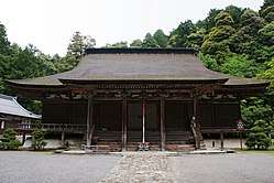
Kōra is famous for Saimyō-ji Temple (西明寺). It is also known as a hometown of Amako clan, Tōdō Takatora and master carpenters who built Nikkō Tōshō-gū.
Geography
Kōra is located within the foot of Suzuka Mountains, with most of the town is located within low grounds. The Inukami River passes through this town.
Neighbouring municipalities
Transportation
Railway
Highways
External links

- Kōra official Website (in Japanese)
| Core city | ||
|---|---|---|
| Cities | ||
| Districts | ||
This article is issued from
Wikipedia.
The text is licensed under Creative Commons - Attribution - Sharealike.
Additional terms may apply for the media files.