Kōnan, Kōchi
| Kōnan 香南市 | |||
|---|---|---|---|
| City | |||
| |||
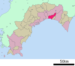 Location of Kōnan in Kōchi Prefecture | |||
 Kōnan Location in Japan | |||
| Coordinates: 33°34′N 133°42′E / 33.567°N 133.700°ECoordinates: 33°34′N 133°42′E / 33.567°N 133.700°E | |||
| Country | Japan | ||
| Region | Shikoku | ||
| Prefecture | Kōchi Prefecture | ||
| Area | |||
| • Total | 126.75 km2 (48.94 sq mi) | ||
| Population (October 1, 2016) | |||
| • Total | 32,786 | ||
| • Density | 260/km2 (670/sq mi) | ||
| Time zone | UTC+9 (JST) | ||
| Website |
www | ||


Kōnan (香南市 Kōnan-shi) is a city located in Kōchi Prefecture, Japan.
As of October 2016, the city has an estimated population of 32,786 and a population density of 260 persons per km². The total area is 126.75 km².
The modern city of Kōnan was established on March 1, 2006, from the merger of the towns of Akaoka, Kagami, Noichi and Yasu, and the village of Yoshikawa (all from Kami District), which was dissolved as a result of this merger and the merger on the same day that created the new city of Kami.
External links

- Kōnan City official website (in Japanese)
| Core city | ||
|---|---|---|
| Cities | ||
| Districts | ||
This article is issued from
Wikipedia.
The text is licensed under Creative Commons - Attribution - Sharealike.
Additional terms may apply for the media files.