Kōdōkan (Mito)
The Kōdōkan (弘道館) was the largest han school in the Edo period. Located in Mito, Ibaraki Prefecture, Japan, three of its buildings have been designated Important Cultural Properties and the school is a Special Historic Site.[1]
History
The Kōdōkan was founded in 1841 by Tokugawa Nariaki, ninth Daimyō of the Mito Domain.[2][3] Admission was at age 15, and the curriculum included medicine, mathematics, astronomy, Confucianism, history, music, and military arts.[4][5] Tokugawa Yoshinobu was confined at the Kōdōkan after abdicating in 1867.[4] The school closed in 1872 after the Meiji Restoration and the introduction of the new school system.[5] In the main building hangs a kakemono inscribed 'Son-jo', an abbreviation of the contemporary slogan Sonnō jōi, 'Revere the Emperor, expel the foreigners'.[4] The Kōdōkan was damaged in the 2011 Tōhoku earthquake and tsunami.[6]
Buildings
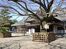
- Seichō (正庁) (1841) (Important Cultural Property)[7]
- Shizendō (至善堂) (1841) (ICP)[8]
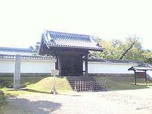
- Seimon (正門) (1841) (ICP)[9]
- Confucian temple; a common feature of han schools, since the doctrine was interpreted as underpinning the four orders of society, with the samurai at the top.[5][10]
See also
References
- ↑ "Database of Nationally-Designated Cultural Properties etc". Agency for Cultural Affairs. Retrieved 5 May 2011.
- ↑ "Ibaraki: Travel Information - Kōdōkan (Mito City)". Ibaraki Prefecture. Archived from the original on 22 May 2011. Retrieved 5 May 2011.
- ↑ "Kodokan Hall". Mito City. Retrieved 6 May 2011.
- 1 2 3 Schreiber, Mark (14 November 2008). "From Mitsukuni to natto". The Japan Times. Retrieved 5 May 2011.
- 1 2 3 "Kodokan". Ibaraki Prefecture. Retrieved 5 May 2011.
- ↑ "Damages to Cultural Properties in "the Great East Japan Earthquake"" (PDF). Agency for Cultural Affairs. Retrieved 5 May 2011.
- ↑ "Database of Nationally-Designated Cultural Properties etc". Agency for Cultural Affairs. Retrieved 5 May 2011.
- ↑ "Database of Nationally-Designated Cultural Properties etc". Agency for Cultural Affairs. Retrieved 5 May 2011.
- ↑ "Database of Nationally-Designated Cultural Properties etc". Agency for Cultural Affairs. Retrieved 5 May 2011.
- ↑ Kazuo, Nishi; Kazuo, Hozumi (1995). What is Japanese architecture?. Kodansha. p. 92. ISBN 978-4-7700-1992-9.
External links
| Wikimedia Commons has media related to Kōdōkan (Mito). |
- (in English) Kōdōkan - English language page
- (in Japanese) Kōdōkan - homepage
Coordinates: 36°22′31″N 140°28′37″E / 36.37528°N 140.47694°E