Junction, Illinois
| Junction, Illinois | |
|---|---|
| Village | |
 Location of Junction in Gallatin County, Illinois. | |
.svg.png) Location of Illinois in the United States | |
| Coordinates: 37°43′22″N 88°14′17″W / 37.72278°N 88.23806°WCoordinates: 37°43′22″N 88°14′17″W / 37.72278°N 88.23806°W | |
| Country | United States |
| State | Illinois |
| County | Gallatin |
| Area[1] | |
| • Total | 0.88 sq mi (2.28 km2) |
| • Land | 0.88 sq mi (2.27 km2) |
| • Water | 0.00 sq mi (0.01 km2) |
| Population (2010) | |
| • Total | 129 |
| • Estimate (2016)[2] | 121 |
| • Density | 137.81/sq mi (53.22/km2) |
| Time zone | UTC-6 (CST) |
| • Summer (DST) | UTC-5 (CDT) |
| ZIP Code(s) | 62954 |
| Area code(s) | 618 |
| FIPS code | 17-38778 |
| Wikimedia Commons | Junction, Illinois |
Junction is a village in Gallatin County, Illinois, United States. The population was 129 at the 2010 census.[3]
Geography
Junction is located at the center of Gallatin County at 37°43′22″N 88°14′17″W / 37.72278°N 88.23806°W (37.722726, -88.237973).[4]
According to the 2010 census, Junction has a total area of 0.883 square miles (2.29 km2), of which 0.88 square miles (2.28 km2) (or 99.66%) is land and 0.003 square miles (0.01 km2) (or 0.34%) is water.[3]
History
The low-lying town has been plagued by Ohio River floods in 1937 and again in 1997.
The Island Riffle variety of watermelon is a popular crop in the area.
Demographics
| Historical population | |||
|---|---|---|---|
| Census | Pop. | %± | |
| 1910 | 800 | — | |
| 1920 | 321 | −59.9% | |
| 1930 | 292 | −9.0% | |
| 1940 | 320 | 9.6% | |
| 1950 | 239 | −25.3% | |
| 1960 | 238 | −0.4% | |
| 1970 | 199 | −16.4% | |
| 1980 | 192 | −3.5% | |
| 1990 | 201 | 4.7% | |
| 2000 | 139 | −30.8% | |
| 2010 | 129 | −7.2% | |
| Est. 2016 | 121 | [2] | −6.2% |
| U.S. Decennial Census[5] | |||
As of the census[6] of 2000, there were 139 people, 66 households, and 43 families residing in the village. The population density was 156.7 people per square mile (60.3/km²). There were 75 housing units at an average density of 84.5 per square mile (32.5/km²). The racial makeup of the village was 96.40% White, 2.88% Native American and 0.72% Asian. Hispanic or Latino of any race were 2.88% of the population.
There were 66 households out of which 25.8% had children under the age of 18 living with them, 45.5% were married couples living together, 18.2% had a female householder with no husband present, and 34.8% were non-families. 33.3% of all households were made up of individuals and 19.7% had someone living alone who was 65 years of age or older. The average household size was 2.11 and the average family size was 2.65.
In the village, the population was spread out with 18.7% under the age of 18, 9.4% from 18 to 24, 24.5% from 25 to 44, 29.5% from 45 to 64, and 18.0% who were 65 years of age or older. The median age was 44 years. For every 100 females, there were 80.5 males. For every 100 females age 18 and over, there were 73.8 males.
The median income for a household in the village was $33,750, and the median income for a family was $34,219. Males had a median income of $34,167 versus $27,083 for females. The per capita income for the village was $16,256. There were 3.8% of families and 11.1% of the population living below the poverty line, including no under eighteens and 41.4% of those over 64.
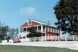
Old Slave House historic site
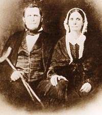
The Hickory Hill mansion, almost five miles west of Junction is the home of the saltmaker and kidnapper illegal slave trader and slave breeder John Hart Crenshaw which was infamously known as the "Old Slave House" used as a criminal front for the kidnapping of free blacks who were illegally sold into the Southern slave trade and a farm for illegal slave breeding on the Reverse Underground Railroad, is located about 3 miles (4.8 km) west of Junction, in Equality Township.
Notable people
- John Hart Crenshaw, landowner, salt maker, illegal slave trader kidnapper, and illegal slave breeder
Further reading
- 1887. History of Gallatin, Saline, Hamilton, Franklin and Williamson Counties, Illinois. Chicago: Goodspeed Publishing Co.
- Musgrave, Jon, ed. 2002. Handbook of Old Gallatin County and Southeastern Illinois. Marion, Ill.: IllinoisHistory.com. 464 pages.
- Musgrave, Jon. 2004, Rev. ed. 2005. Slaves, Salt, Sex & Mr. Crenshaw: The Real Story of the Old Slave House and America's Reverse Underground R.R.. Marion, Ill.: IllinoisHistory.com. 608 pages.
References
- ↑ "2016 U.S. Gazetteer Files". United States Census Bureau. Retrieved Jun 29, 2017.
- 1 2 "Population and Housing Unit Estimates". Retrieved June 9, 2017.
- 1 2 "G001 - Geographic Identifiers - 2010 Census Summary File 1". United States Census Bureau. Retrieved 2015-08-04.
- ↑ "US Gazetteer files: 2010, 2000, and 1990". United States Census Bureau. 2011-02-12. Retrieved 2011-04-23.
- ↑ "Census of Population and Housing". Census.gov. Archived from the original on May 12, 2015. Retrieved June 4, 2015.
- ↑ "American FactFinder". United States Census Bureau. Retrieved 2008-01-31.
External links
Municipalities and communities of Gallatin County, Illinois, United States | ||
|---|---|---|
| City | ||
| Villages | ||
| Townships | ||
| Unincorporated communities | ||