John Street (Markham)
| |
|---|---|
| Route information | |
| Maintained by the City of Markham Transportation department | |
| Length | 6.125 km (3.806 mi) |
| Existed | 1800s – present |
| Major junctions | |
| West end |
|
|
| |
| East end |
|
| Location | |
| Major cities | Markham |

John Street is an east-west collector and arterial road in the city of Markham, Ontario. It is one of the oldest roads in the city of Markham and forms the backbone of the 200-year-old community of Thornhill.
The street originally ran east from Yonge Street across a tributary of the Don River, at which point it branched north to what is now Leslie Street and south on German Mills Road. This was a travelled road which did not match the alignment of any concession road or lot line and was constructed along the most convenient route to farms and mills to serve the needs of the inhabitants at that time. In the late 20th century an extension was made across Highway 404 and through an industrial area to connect to Woodbine Avenue, east of which it joins with Esna Park Drive.
John Street has had a major impact in shaping the community; the parallel Green Lane/14th Avenue east-west road allowance has never been fully opened and Leslie Street still diverts from the route laid out by the township survey to join Don Mills Road near the former easterly end of John Street.
Description
John Street is a four-lane arterial road between Woodbine Avenue and Bayview Avenue, and, due to the presence of Old Thornhill, a two-lane collector road between Bayview and Yonge Street. John Street serves to relieve traffic on Steeles Avenue, and Highway 7. John Street also serves as a western extension of 14th Avenue via Alden Road and Esna Park Drive. The combined route is designated York Regional Road 71, which also includes part of Centre Street in the City of Vaughan.
This part of John Street has one bridge, and one steep valley. Between Leslie Street, and Bayview Avenue, the street heads into a steep valley, and rise up again shortly to meet Aileen Road. During that part of the road, John Street has 7 intersections with traffic lights. The road is fairly straight, and heads in a northwesterly direction.
Between Bayview Avenue and Yonge Street, John Street is two lanes wide. During that section of the road, there are several stop signs. This part of John street goes up and down through valleys and ridges. As it approaches to Pomona Mills Park, the landscape becomes more level. During this section of the road, the roadway is narrow.
Between Woodbine Avenue and Ontario Highway 404, all zonings are industrial. Between Highway 404 and Bayview Avenue, a mix of light industrial with rail spur service and medium-density residence along the road. When the road approaches Yonge Street, light residential areas are found.
John Street forms a link in what is otherwise the first concession road north of Steeles Avenue, with 14th Avenue, Centre Street, and the portion of Highway 7 west of Dufferin Street. However, due to the aforementioned presence of Old Thornhill and the desire to eliminate a jog in Highway 7 by the Province of Ontario, the road alignment was never developed into a single, continuous cross-region arterial.
History
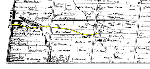
This road, along with any side streets in Thornhill, are one of the oldest roads in Markham, with over 200 years of history. The road is believed to be built in the 19th century, named after John Colborne along with Colborne Street, immediately south of John Street.[1] John Street was believed to be built around 1828-1836. Prior to that, Thornhill was a little community with houses along Yonge Street. John Street allowed eastward developments. The development of Thornhill in the 19th century stopped at what is now Henderson Avenue, and along the section of John Street between Yonge Street and Henderson Avenue are developments from that time.[2] The area is now preserved under the city of Markham's Heritage Department. Along John Street in this area, the road signs are labelled as "Old Thornhill Circa 1794". This part of John Street is also considered as the heart of Old Thornhill.
The road is also home to the Sutton Frizzel's house. Originally located on Yonge and Royal Orchard, it was moved in the 20th century due to the widening of Yonge Street. It was built by the Tory Loyalist in the 19th century, and its original occupants played a significant role in the Rebellions of 1837.[1]
In the 20th century, as Markham's population rapidly grew, John Street was extended to its current length, with modern housing along the road.
In 2004, the corner of John and Bayview is under redevelopment of medium dense residential. This new redevelopment is referred to as "Olde Thornhill Village".[3]
Landmarks
- Sutton Frizzell's House, 18 John Street.
- Thornhill Cemetery (1867)
- Pomona Mills Park
- Thornhill Community Centre has two ice rinks rink, 3 community halls, an auditorium and a library.
- John Welsh House (known as Thornlea), 288 John Street, now 'Santorini Bar & Grill'
- Thornhill Square Shopping Centre, 300 John Street, now mostly demolished and replaced by a Townhouse development.
- R.J. Clathworthy Arena is equipped with one ice rink.
- Bishops Cross Park has a major baseball and soccer field, along with playgrounds and running track.
Public transit
The York Region Transit operates the YRT Route #2 (Milliken), servicing almost the entire route of John Street east of Henderson Avenue. In addition, the Toronto Transit Commission also serves the industrial park near the east end of John Street with TTC Route #224C.
Intersecting roads

- Nolan Court
- Steelcase Road

- Rockingham Court
- Chestnut Gate
- Cottonwood Court
- Dawn Hill Trail
- Bayview Fairways Drive
- Aileen Road
- Porterfield Crescent

- Bayfield Gate / Candice Gate
- Johnson Street
- Henderson Avenue
- Deanbank Drive
- Leahill Drive
- Summer Lane
- Paul Street
- Church Lane
- Marie Court
- Confederation Way / Dudley Avenue

References
- Maps
- MapArt: Golden Horseshoe, Greater Toronto Area Pages 355 and 356, Grids Y21, Y22, Y23, Y24, Y25, Y26, and Y27.
- Maps And Aerial Photos of John Street
- TTC/ Transit maps
- Multi-Languages Transit Guide Versions 1/2
- Notes
- 1 2 "The Society for the Preservation of Old Thornhill". Archived from the original on 2008-05-09. Retrieved 2008-06-09.
- ↑ "Town of Markham - Heritage and History". Archived from the original on October 12, 2007. Retrieved 2008-06-09.
- ↑ "Olde Thornhill Village". Archived from the original on 2008-05-06. Retrieved 2008-06-09.
| East-West Municipal Roads: |
| |
|---|---|---|
| North-South Municipal Roads: |
| |
| Regional Roads: | ||
| Highways and Expressways: | ||
| See also | ||